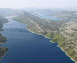
The narrow sea from Zaliv Klek Neum is 4 NM long and lies at the NE channel Malog Stone. It is surrounded by mountains and is inserted between Rt Rep Kleka and Rt Meded. Depths exceeding 20 meters in most cases. There are several anchorages. The SE part and W peninsula belong to Bosnia-Herzegovina. Neum is the only seaside town in Bosnia-Herzegovina. It has about 21 km of coastline which is the only access to the Adriatic Sea. This access crosses the Croatian coast about ten km, but the maritime access is longer since the land has an isthmus parallel to the coast that gives birth to a bay to the W, which is the city.
This poses no problem for visiting yachts.
2011/05/3
Update
Jojo
Le bras de mer étroit de Zaliv Klek Neum fait 4 M de long et se trouve au NE du canal Malog Stona. Il est entouré de montagnes et s'insère entre Rt Rep Kleka et Rt Meded.
Les profondeurs dépassent le plus souvent 20 m. Il y a plusieurs mouillages.
La partie SE et la péninsule à l'W appartiennent à la Bosnie-Herzégovine. Neum est la seule ville maritime de Bosnie-Herzégovine. Elle compte environ 21 km de côte qui constitue le seul accès à la mer Adriatique. Cet accès coupe la côte Croate sur une dizaine de km, mais l'accès maritime est plus long puisque le territoire comprend un isthme parallèle à la côte qui donne naissance à une baie vers l'W, sur laquelle se trouve la ville.
Cela ne pose aucun problème aux yachts de passage.
It is the largest and most populated island of the group Elafiten. It rises to 234 m at its N and a prominent hill rises 224 m NW of the SE end. Ruda is a small island that is 0.5 M SE of the NE extremity of the island and Misnjaka, 13 m high, lies close off the NW extremity. ...
Stonski Kanal, a deep inlet, indents the SE end of Poluotok Peljesac at the NW end of Kolocepski Kanal. Its shore rises rapidly on each side and provides protection from NE and SW winds. The village of Brocej is situated on the S shore 3.8 miles within the entrance. It is fronted ...
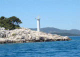
This island is situated at the entrance to Uvala Klek, SE tip W. It wears a small chapel but did not have a lighthouse. It is possible to to pass near the island in N where the funds are 5.5 m.
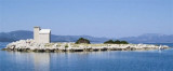
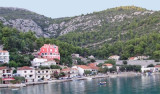
Uvala Klek is a large bay housing a small town famous for its numerous historical monuments. At the bottom of the bay is a great beach and SE of the peak W there is an island (O. Kojestac) with a chapel. We anchored off the beach by about 8 m .
Uvala Duboka is located at Zaliv Klek Neum enter, N Rt Maded. At the bottom of the bay there are few homes and a small dock.We can anchor by 5 to 8 m.Open to SE.


 The narrow sea from Zaliv Klek Neum is 4 NM long and lies at the NE channel Malog Stone. It is surrounded by mountains and is inserted between Rt Rep Kleka and Rt Meded.
 Le bras de mer étroit de Zaliv Klek Neum fait 4 M de long et se trouve au NE du canal Malog Stona. Il est entouré de montagnes et s'insère entre Rt Rep Kleka et Rt Meded.