
Bahia de Santo Antonio (F de Noronha N Brazil)
751nm
254°
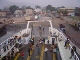
A stone pier was built for tieing up small ships. Bigger ...
12 Jan 16
Joëlle
| Latitude | Longitude | |
| DMS | --- | --- |
| DM | --- | --- |
| DD | --- | --- |

 The Romanche Trench, also called the Romanche Furrow or Romanche Gap, is the third deepest of the major trenches of the Atlantic Ocean, after the Puerto Rico Trench and the South Sandwich Trench. It bisects the Mid-Atlantic Ridge just north of the equator at the narrowest part of the Atlantic between Brazil and West Africa, extending from 2°N to 2°S and from 16°W to 20°W.
 La fosse Romanche ou fosse de la Romanche (aussi appelé sillon Romanche, faille Romanche ou Zone de fracture Romanche) est la troisième plus profonde fosse océanique de l'océan Atlantique, après la fosse de Porto Rico et la fosse des Sandwich-du-sud. Elle découpe la dorsale médio-Atlantique, juste au nord de l'équateur, au point le plus étroit entre le Brésil et l'Afrique de l'Ouest, s'étendant de 2°N à 2°S de latitude et de 16°W à 20°W de longitude.
Ebook | Gulf of Guinea
|