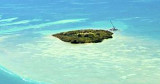
Long Key (ou Rattlesnake key) (Florida Keys)
5.9nm
242°
In the early 20th century, Long
Key was the site of a luxurious fishing resort that ...
5 Apr 10
Joëlle
| Latitude | Longitude | |
| DMS | --- | --- |
| DM | --- | --- |
| DD | --- | --- |


 15 amp only

 Hungry Tarpon: 305 664 0535
 Just N of the 10 foot span, Robbie's Marina overlooks the western flank of Lignumvitae Channel. A large shoal separate this facility's docks from the channel. This hazard is indicated by a series of floats on a rope. To safety access the marina, you must cruise either south or north of this shoal. Take your time, this is not an easy entry.
Remember that the current in the channel can get very, very strong, so you need to pick your times carefully and make no errors.
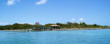
Robbie's Marina is smallish, with an old Florida look, ripe with fishing boats of some years.
The dockage consists of mostly fixed wooden finger piers, but their state of repair is a bit depleted.
This marina has no showers or other amenities that most cruisers deem necessary.
Nevertheless, transients are accepted, though many of the slips are occupied by local craft.
The big attraction at Robbie's is the presence of free-swimming Tarpon (and jacks) that have become accustomed to people feeding them by hand.
Phone: (305) 664 9814
")
")
")
")
Ebook | Gulf of Mexico
|
 Juste au N de la travée de 10 pieds, Marina Robbie's domine le flanc W du canal de Lignumvitae. Un grand haut-fond sépare cette marina du canal. Ce danger est indiqué par une série de flotteurs sur une corde. Pour accéder à la marina en toute sécurité, vous devez de naviguer soit au sud ou au nord de ce haut-fond. Prenez votre temps, ce n'est pas une entrée facile.
Tel: (305) 664 9814