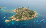
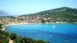
Isola dell’Ogliastra, 47m high, lies 3 miles S of Punta Pedra Longa and is in front of Lotzorai beach. It is reddish, rocky, and covered with scanty vegetation.
Several rocks extend up to 0.2 mile seaward off its NE side.
There are many coves that offer tamporal anchorage .
The passage leading between the islet and the coast is 0.5 mile wide and has a depth of 8.5m in the fairway.
2012/10/10
Update
Joëlle
L'île dell'Ogliastro, haute de 47 m, se trouve à 3 MN au S de la pointe Pedra Longa et fait face à la plage Lotzorai. Elle est de couleur rouge, rocheuse et recouverte d'une végétation peu abondante.
Elle est débordée par plusieurs rochers jusqu'à 0,2 MN au large de sa côte NE.
De nombreuses criques offrent un mouillage Temporel.
Le passage entre l'îlot et la côte est de 0,5 mile de large et a une profondeur de 8,5 m dans le chenal.
2012/10/10
Update
Joëlle
Isola dell'Oligastro, 47 m di altezza, si trova a 3 MN S punta Pedra Longa e si affaccia sulla spiaggia di Lotzorai. È rossa, rocciosa e coperta di vegetazione rada.
E' sopraffatta da rocce diverse fino a 0,2 MN al largo della sua costa NE.
Numerose calette forniscono un ancoraggio temporale.
Il passaggio tra l'isola e la costa è di 0,5 km di larghezza ed ha una profondità di 8,5 m nel canale.
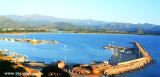
Gulf di Tortoli is entered between Isola dell’Ogliastra and Capo Bellavista, marked by a light, 2.5 miles S. Winds from the NW and NE quadrants come up suddenly and blow with extreme violence in this vicinity. They may last for 4 or 5 days and are preceded by whitish clouds ...
Anchorage can be taken, in a depth of 15m, sand and weed, about 0.2 mile SSW of Isola dell’Ogliastra or in a depth of 8m, about 200m W of the islet, but these berths are dangerous in SE winds.
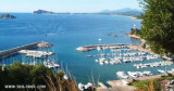
The port of Arbatax lies in the S part of Golfo di Tortoli and on the N side of the promontory of Capo Bellavista. It is the only refuge on the E coast of Sardegna to the S of Olbia.
Tel. 0782.667405 Fax 0782.664359 Berths: 400 Berths Transit: 150 (<80 m)
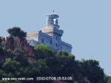
Bellavista cape is a rugged promontory, 150 m high and connected to the shore by a lower land, so that, seen from N or S, it seems an island. It has a lighthouse at its peak, crenellated tower 19 m high, backed by a one floor house, painted in black and white horizontal stripes. ...
S Bellavista cape, between Sud S. Gemiliano point and N Frailis point, leads a small bay with a beautifull sandy beac. On the W point of the entry we see S. Gemiliano tower, 42 m high. N promontory is the Arbatax harbour.Beware to numerous rocks present in the bay.We anchor in ...


 Isola dell’Ogliastra, 47m high, lies 3 miles S of Punta Pedra Longa and is in front of Lotzorai beach. It is reddish, rocky, and covered with scanty vegetation.
 L'île dell'Ogliastro, haute de 47 m, se trouve à 3 MN au S de la pointe Pedra Longa et fait face à la plage Lotzorai. Elle est de couleur rouge, rocheuse et recouverte d'une végétation peu abondante.
 Isola dell'Oligastro, 47 m di altezza, si trova a 3 MN S punta Pedra Longa e si affaccia sulla spiaggia di Lotzorai. È rossa, rocciosa e coperta di vegetazione rada.
")
")
")