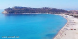
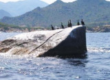
Serpentara island is 1,7 NM off the coast. It is flat and bare and N is extended by a shoal which emerge 3 large rocks. You can anchor between the island and the earth, at 1 NM SSW Cala Pira tower.
2012/10/14
Update
Joëlle
L'île Serpentara déborde la côte à 1,7 M. Elle est plate et dénudée et est prolongée au N par un haut-fond d'où émergent trois gros rochers. On peut mouiller entre l'île et la terre, soit à 1 M au SSE de la tour de Cala Pira.
2012/10/14
Update
Joëlle
L'isola di Serpentara è a 1,7 MN della costa. E' piatta e spoglia. Al N E' prorogata di un banco dove emergono tre rocce di grandi dimensioni. E' possibile ancorare tra l'isola e la terra, a 1 MN SSE della torre di Cala Pira.
2012/10/14
Update
Joëlle
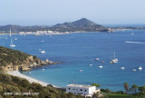
Isola Serpentara (Sardegna)
2010:07:07 15:31:49
2012-10-14
Update
Joëlle
Isola Serpentara (Sardegna)
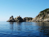
La tour S. Luigi située à l'extrémité N de l'île sur le sommet haut de 54 m
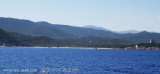
Carbonara gulf is located between Carbonara cape and Boi cape, in the Cagliari gulf, on its E side.Depending on the wind,we anchor on the W or E side of the bay. This large bay, rock and sand bottom, is very pretty and very crowded in summer. NW of Carbonara cape, Carbonara Bay ...
Quartu gulf lies between Foxi tower and S. Elia cape, in the Cagliari Gulf.It is not recommended to anchor in the Quartu bay.Ancorage is also prohibited in a strip between the bearings to 314 ° of Mezza Spiaggia tower and 316 ° to the S. Elia E end cape and extending to 7 NM of shore.
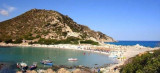
Molentis (dei Molenti) point, 2 NM W S of Serpentara island, end consists of a small headland surrounded by rocks and low, connected to the mainland by a sandbar.
Ancorage by 26 m about halfway between the Molentis tipand Serpentara island.
A little off Turno Mount is S. Elmo rock, some hundred meters from the coast, less than 20 m deep. This rock has the particularity of having, below the level of the sea, a small cave that can be explored by divers.


 Serpentara island is 1,7 NM off the coast. It is flat and bare and N is extended by a shoal which emerge 3 large rocks.
 L'île Serpentara déborde la côte à 1,7 M. Elle est plate et dénudée et est prolongée au N par un haut-fond d'où émergent trois gros rochers.
 L'isola di Serpentara è a 1,7 MN della costa. E' piatta e spoglia. Al N E' prorogata di un banco dove emergono tre rocce di grandi dimensioni.
")
")
")