Pulau Kukup (Johor - Malaysia)

Pulau Kukup (Johor - Malaysia)

To precisely geolocate this site. Update if necessary.

Localisation

Characteristics

Island / Atoll
Natural Park

Description

Pulau Kukup (Johor - Malaysia)
2011-12-29
Update
Jojo
Ebook

Strait of Malacca (East)

  • 83 sites
  • 69 photos
  • publication date: 11 Jul 2023
  • .pdf file size: 35 Mb
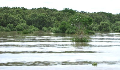
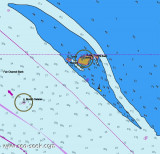
Located South-west of Johor, about 5,5 NM NW of Tg Piai, 1 km offshore from the quaint little fishing village of Kampung Air Masin in Kukup Laut (Pontian District), Pulau Kukup is an low, flat island entirely covered by mangrove forest and surrounded by mudflats - the mudflats extend up to a few kilometres on the West and Northwest of the island.
There is currently no human habitation or man made structures on the island.

In order to promote preservation of this unique mangrove habitat, Pulau Kukup is designated as a Ramsar site (or otherwise known as a Wetlands of International Importance) on 31 January 2003, it is also protected as a national park under the Johor State Park Corporation Enactment 1989 since 27 March 1997.

Pulau Kukup is dissected by a few tidal creeks and channels.In passing Pulau Kukup, caution must be exercised because the E current sets strongly toward the shore and the W current toward Long Bank on the opposite side of the fairway.
2012/01/6
Update
Jojo
Ebook

Sumatra (Indonesia)

  • 326 sites
  • 109 photos
  • publication date: 6 Jul 2023
  • .pdf file size: 100 Mb
Share your comments or photos on "Pulau Kukup (Johor - Malaysia)"

Sites around Pulau Kukup (Johor - Malaysia)

Flying distances - Direct line

Pulau Karimun Kecil (E Sumatra)

10nm
196°
Karimun Kecil or Little Karimun, separated from the NE side of Great Karimun by a deep channel about 0.5 mile wide, is a bold island, 377m high.
In the NW approach to the channel between Great Karimun and Little Karimun are two islets, Nangoi, 39m high, about 1.2 miles W of the ...
1 Feb 12
Jojo

Pulau Tekong

37nm
82°
Small island on the east side of Singapre, close to Malaysia.Access is reserved to military activities and personnels.
17 May 11
Wikiadmin2

Pulau Assan and Mudu (E Sumatra)

14nm
212°
Assan and Mudu, rocky and thickly-overgrown islands, 83 and 65m high, respectively, lie about 1.2 miles off the NW side of Great Karimun. Sajuda, an above-water rock, lies 0.5 mile N of Assan and Seal Rock lies about 0.5 mile NE of Sajuda.
Tokong Belanda, a low rock, lies about ...
31 Jan 12
Jojo

Pulau Pisang (Johor - Malaysia)

13nm
309°
Pulau Pisang (English: Banana island) is a small island located off the Western coast of the Malaysian state of Johor. It is about 12 km from the town of Pontian Kecil and 5 km from Benut town. It is the siteof Pisang Lighthouse guiding ships into the western entrance of the Singapore ...
6 Jan 12
Jojo

Pulau Lyu Besar and Lyu Kecil (E Sumatra)

9.4nm
210°
Pulau Iyu Besar and Pulau Iyu Kecil, each 45m high, lie about 3 miles N of Little Karimun.
Pulau Iyu Kecil lies 0.5 mile NE of Pulau Iyu Besar. The islets are known as The Brothers.
A rock, with a depth of 2m, lies 0.3 mile NE of Pulau Iyu Kecil, and a rock, with a depth of ...
1 Feb 12
Jojo

Raffles Marina

12nm
84°
Raffles Marina offers 158 walk-on wet berths catering for boats up  to 20m, or 65 ft in length. The marina?s solid panel breakwater
provides the calmest marina lagoon in Singapore, with an average lagoon depth of 4 metres at LAT.
Features
Single or Double Berths ...
4 Apr 12
cop