Pulau Karimun Kecil (E Sumatra)
10nm
196°
In the NW approach to the channel between Great Karimun and Little Karimun are two islets, Nangoi, 39m high, about 1.2 miles W of the ...
1 Feb 12
Jojo
| Latitude | Longitude | |
| DMS | --- | --- |
| DM | --- | --- |
| DD | --- | --- |


")
Ebook | Strait of Malacca (East)
|
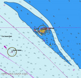
 Located South-west of Johor, about 5,5 NM NW of Tg Piai, 1 km offshore from the quaint little fishing
village of Kampung Air Masin in Kukup Laut (Pontian District), Pulau
Kukup is an low, flat island entirely covered by mangrove forest and surrounded by
mudflats - the mudflats extend up to a few kilometres on the West and
Northwest of the island.
Located South-west of Johor, about 5,5 NM NW of Tg Piai, 1 km offshore from the quaint little fishing
village of Kampung Air Masin in Kukup Laut (Pontian District), Pulau
Kukup is an low, flat island entirely covered by mangrove forest and surrounded by
mudflats - the mudflats extend up to a few kilometres on the West and
Northwest of the island.In order to promote preservation of this unique mangrove habitat, Pulau Kukup is designated as a Ramsar site (or otherwise known as a Wetlands of International Importance) on 31 January 2003, it is also protected as a national park under the Johor State Park Corporation Enactment 1989 since 27 March 1997.
Pulau Kukup is dissected by a few tidal creeks and channels.In passing Pulau Kukup, caution must be exercised because the E current sets strongly toward the shore and the W current toward Long Bank on the opposite side of the fairway.Ebook | Sumatra (Indonesia)
|