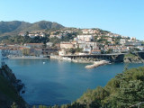
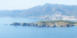
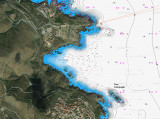
This fishing port has recently been upgraded and converted into a small modern marina. However the cove is exposed E wind and open at ground swell.
It is possible to anchor opposite the beach by about 6-8 meters of good behavior, but it is not protected from the swell.
Wearing Portbou be avoided by wind E.
T. (+34) 972 390 712 F. (+34) 972 125 123 M. portdeportbou@telefonica.net 297b. (<20 m)
Etymologically "Portbou" means "fishing harbour", "bou" can refer to both the typical fishing boats, but also in Catalan an abacus, a large fishing net that boats lying on the sand along the coast or a beef animal used for pulling boats.
2012/07/14
Update
Jojo
Ce port de pêche vient d'être aménagé et reconvertis en un petit port de plaisance moderne. Cependant l'anse de Portbou est exposée au vent d'E et ouverte à une forte houle.
Il est possible de mouiller face à la plage par environ 6-8 mètres de bonne tenue, mais peu protégé de la houle. Le port de Portbou est à éviter par vent d'E.
T. (+34) 972 390 712
F. (+34) 972 125 123
M. portdeportbou@telefonica.net
297pl. (<20 m)
Étymologiquement « Portbou » signifie « port de pêcheurs », bou peut désigner à la fois les barques de pêche typiques, mais aussi en catalan un boulier, un grand filet de pêche que des bateaux traînent sur le sable le long des côtes ou encore un boeuf, animal utilisé pour tirer les barques.
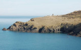
Cerbere, a small cove, is entered between Cap Cerbere and Cap Canadell, 0.5 mile NW. It offers sheltered anchorage to small vessels from winds from the S through W to N.
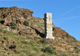
Cerbere Cape is formed by steep cliffs which rise abruptly to a plateau. It is the E termination of Chaine des Alberes, a rugged and prominent mountain range. It is the ultimate Frecn flagship before the Franco-Spanish border, also called "Solar flagship".From seaward, ...


 7 mètres
 Canal 9


 This fishing port has recently been upgraded and converted into a small modern marina. However the cove is exposed E wind and open at ground swell.
 Ce port de pêche vient d'être aménagé et reconvertis en un petit port de plaisance moderne. Cependant l'anse de Portbou est exposée au vent d'E et ouverte à une forte houle.
 Portbou bay