Cerbere Cape is formed by steep cliffs which rise abruptly to a plateau. It is the E termination of Chaine des Alberes, a rugged and prominent mountain range. It is the ultimate Frecn flagship before the Franco-Spanish border, also called "Solar flagship".
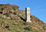
From seaward, the cape has a triangular shape and its summit is surmounted by a small white building.
A solar lighthouse (powered by solar panels) is shown from a structure consisting of a grey tower with curved buttresses and a red roof standing on the extremity of the cape. A radio tower is situated close W of the light.
2012/07/16
Update
Jojo
2012-07-16
Update
Jojo
Le cap Cerbère est formé par des falaises abruptes qui s'élèvent abruptement derrière un plateau. Il est la fin de la Chaine E des Albères, une chaîne de montagnes proéminente. C'est l'ultime phare français avant la frontière franco-espagnole, appelé aussi « phare solaire ».
Du large, le cap a une forme triangulaire et son sommet est surmonté d'un petit bâtiment blanc.
Un phare solaire (alimenté par des panneaux solaires) s'élève sur l'extrémité du cap à partir d'une structure composée d'une tour grise avec des contreforts courbes et un toit rouge. Une balise radio se trouve à l'W du feu.
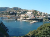
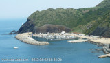
Cerbere, a small cove, is entered between Cap Cerbere and Cap Canadell, 0.5 mile NW. It offers sheltered anchorage to small vessels from winds from the S through W to N.
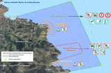
Réserve Marine La réserve est bornée par deux balises jaunes, facilement repérées entre le Cap Peyrefite et le Cap Bear, avant Banyuls. La réserve intégrale est quant à elle, localisée sur le Cap Rédéris. A cet endroit la nature y est sanctuarisée dans le but de ...


 Cerbere Cape is formed by steep cliffs which rise abruptly to a plateau.
 Le cap Cerbère est formé par des falaises abruptes qui s'élèvent abruptement derrière un plateau.