Puerto de Mejillones del Sur (Antofagasta N Chile)
Latitude
Longitude
DMS
---
---
DM
---
---
DD
---
---
Characteristics
9, 14, 16
Description
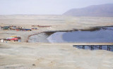
Mejillones lies on the S shore of Bahia Mejillones del Sur. The port consists of passenger berths (Muelle Fiscal), one fishing vessel berth, and one terminal with three mooring buoys for the discharge of ammonia.
Tel: 56 55 657060 Mail: contacto@mejillones.com
2012/12/21
Update
Joëlle
Le port de Mejillones est situé au S de la baie de Mejillones del Sur. Le port est composé d'un quai d'accueil des passagers (muelle Fiscal), d'un port de pêche, et un terminal, avec trois bouées de mouillage, pour la décharge de l'ammoniac.
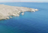
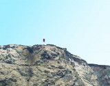
Located about 11 NM SW of Punta Chacaya, Punta Angamos is 220 m high and extends N. It is entirely covered with guano, wich gives it the appearance of a chalky cliff. A light is shown from the point.
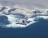
The Punta Lagartos is in front of a bank (banco Lagartos) that lies at 0,5 NM from it. Islote Lagartos is at about the center of the bank. the islet is 4,9 to 5,8 m high. It is rock covered with white shells and can be recognized for 3 NM.Rocks extend some distance NW and S from ...
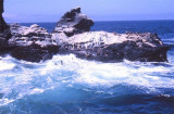
Santa Maria island is between caleta Constitucion and caleta Errazuriz. Reefs extend a little over 0.5 mile SSW from the S side of the island and up to 0.3 mile from all other sides.
Caleta Constitucion is entered NE of isla Santa Maria. The entrance between the reefs, which extend N from the island and those which extend about 0.3 NM S from the N entrance point, is about 0.5 NM wide and has a least depth of 13.7m. A channel, about 180 m wide at its narrowest ...


 9, 14, 16

 Mejillones lies on the S shore of Bahia Mejillones del Sur. The port consists of passenger berths (Muelle Fiscal), one fishing vessel berth, and one terminal with three mooring buoys for the discharge of ammonia.
 Le port de Mejillones est situé au S de la baie de Mejillones del Sur. Le port est composé d'un quai d'accueil des passagers (muelle Fiscal), d'un port de pêche, et un terminal, avec trois bouées de mouillage, pour la décharge de l'ammoniac.
")
")