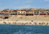
Santa Maria island is between caleta Constitucion and caleta Errazuriz. Reefs extend a little over 0.5 mile SSW from the S side of the island and up to 0.3 mile from all other sides.
2012/12/22
Update
Joëlle
L'île Santa Maria se trouve entre caleta Constitucion et caleta Errazuriz.
Des rochers s'étendent à un peu plus de 0,5 MN vers le SSW à partir du côté S de l'île et à plus de 0,3 MN de tous les autres côtés.
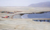
Caleta Constitucion is entered NE of isla Santa Maria. The entrance between the reefs, which extend N from the island and those which extend about 0.3 NM S from the N entrance point, is about 0.5 NM wide and has a least depth of 13.7m. A channel, about 180 m wide at its narrowest ...
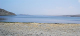
Caleta Errazuriz is S Santa Maria island. The channel between the reefs, which extend SSW from the island and those with extend about 0,3 NM N from the W entrance point of the cove, is about 0,3 NM wide and has depths over 27,4 m.
The Punta Lagartos is in front of a bank (banco Lagartos) that lies at 0,5 NM from it. Islote Lagartos is at about the center of the bank. the islet is 4,9 to 5,8 m high. It is rock covered with white shells and can be recognized for 3 NM.Rocks extend some distance NW and S from ...
Punta Tetas is the SW extremity of Peninsula Moreno. The point is of moderate height, rocky,and arid. Punta Tetas is free of off-lying dangers and a light is shown from it.


")
")
")