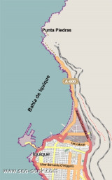

Baia de Iquique (Tarapaca N Chile)
1.6nm
13°
16 Dec 12
Joëlle
| Latitude | Longitude | |
| DMS | --- | --- |
| DM | --- | --- |
| DD | --- | --- |
 9, 14, 16


")
Ebook | Chile
|
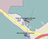
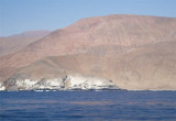
 Iquique is a city-harbour in Tarapac Region. It Iquique is an artificial port composed of a mole (Molo de Union), 480m in length, linking Serrano Island with the mainland. A breakwater (Molo de Abrigo) extends NNE from Penisula Serrano NNE for 846m, marked by a light at the head.
Iquique is principally a fishing port, with local factories producing fish meal, frozen fish, and canned fish. Other cargoes handled include copper concentrates, slag or ores, vegetable and soya oils, and petroleum products.
The harbor is well-protected and large vessels berth alongside for the handling of cargo.
Isla Serrano and the breakwater extending NE from it protect the harbor from the prevailing winds which blow from the S and SW.
Gales off the S part of the coast of Chile cause a swell at Iquique from 2 to 4 days later. During N winds, surf enters the area between the moles sometimes necessitating the reinforcement of mooring lines.
Tel: 56 57 401905
Fax: 56 57 424669
Mail: cpiquique@directemar.cl
 Iquique est une ville portuaire dans la région de Tarapac. C'est un port artificiel composé d'un mole de 480 m de long, reliant l'île Serrano au continent. Un brise-lames (Molo de Abrigo), marqué par une lumière, s'étend au NNE depuis la péninsule Serrano sur 846 m.
 Le port est bien protégé et de gros vaisseaux peuvent accoster pour la manutention des cargaisons.
L'île Serrano et le brise-lames qui s'étend au NE de l'île protègent le port des vents dominants qui soufflent du S et SW.
Les coups de vent au large de la partie S de la côte du Chili provoquent une houle à Iquique 2 à 4 jours plus tard. Lors de grands vents venant du N, une houle pénètre dans la zone située entre les moles parfois nécessitant le renfort de lignes d'amarrage.
")