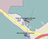
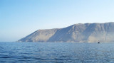
Punta Gruesa is low and cliffy. It forms the end of a spur extending from Morro Tarapaca, a mountain about 4 miles ENE. A light is shown from the point.
Rocas Los Gemelos consist of two sunken rocks which lie at the outer extremity of foul ground which extends about 1.5 NM NW from the N end of Punta Gruesa. Three dark-colored above-water rocks lie about 0.3 NM NE of Punta Gruesa.
2012/12/17
Update
Joëlle
Punta Gruesa est basse et constituée de falaises rocheuses. Elle forme l'extrémité d'un éperon allant de Morro Tarapaca, une montagne à environ 4 MN à l'ENE. La pointe porte un phare.
Los Gemelos, deux rochers immergés, se trouvent à environ 1,5 MN au NW de l'extrémité N de Punta Gruesa. Trois rochers sombres se trouvent à environ 0,3 MN au NE de la pointe.
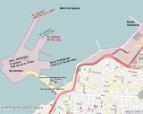
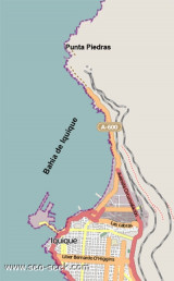
Iquique bay lies between Punta Piedras and Serrano peninsula, 3 NM S.Bahia de Iquique is open to winds between the NW and NE, however, these winds seldom occur. Iquique is ordinarily entirely free from storms of any kind and strong winds are very unusual. The light breezes are ...
Iquique is a city-harbour in Tarapac Region. It Iquique is an artificial port composed of a mole (Molo de Union), 480m in length, linking Serrano Island with the mainland. A breakwater (Molo de Abrigo) extends NNE from Penisula Serrano NNE for 846m, marked by a light at the head. Iquique ...


 Punta Gruesa is low and cliffy. It forms the end of a spur extending from Morro Tarapaca, a mountain about 4 miles ENE. A light is shown from the point.
 Punta Gruesa est basse et constituée de falaises rocheuses. Elle forme l'extrémité d'un éperon allant de Morro Tarapaca, une montagne à environ 4 MN à l'ENE. La pointe porte un phare.
")
")
")