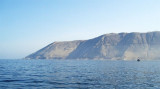
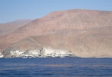
Iquique bay lies between Punta Piedras and Serrano peninsula, 3 NM S.
Bahia de Iquique is open to winds between the NW and NE, however, these winds seldom occur.
Iquique is ordinarily entirely free from storms of any kind and strong winds are very unusual. The light breezes are generally from the SW. Mist frequently obscures the hills behind the town, particularly in the early morning and afternoon. Even the town itself may be obscured at times by a low-lying mist.
2012/12/16
Update
Joëlle
Baia de Iquique (Tarapaca N Chile)
2012-12-16
Update
Joëlle
La baie de Iquique s'étend entre Punta Piedras et la péninsule Serrano, à 3 MN au S.
La baie est ouverte aux vents de NW et NE, mais ces vents se produisent rarement.
Iquique n'est généralement pas une zone de tempêtes et les vents forts sont très rares. Les brises légères sont généralement du SW. La brume s'étend souvent sur les collines derrière la ville, en particulier en début de matinée et d'après-midi. La ville elle même peut être masquée parfois par un brouillard à basse altitude.
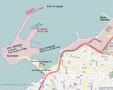
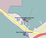
Iquique is a city-harbour in Tarapac Region. It Iquique is an artificial port composed of a mole (Molo de Union), 480m in length, linking Serrano Island with the mainland. A breakwater (Molo de Abrigo) extends NNE from Penisula Serrano NNE for 846m, marked by a light at the head. Iquique ...
Punta Gruesa is low and cliffy. It forms the end of a spur extending from Morro Tarapaca, a mountain about 4 miles ENE. A light is shown from the point.Rocas Los Gemelos consist of two sunken rocks which lie at the outer extremity of foul ground which extends about ...


 Iquique bay lies between Punta Piedras and Serrano peninsula, 3 NM S.
")
 La baie de Iquique s'étend entre Punta Piedras et la péninsule Serrano, à 3 MN au S.