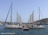
Il y a deux ports de Mazarron: le port de pêche Azohia et Puerto de Mazarron (37°3344, -1°1637) et le port de plaisance Puerto de Mazarron et Isla Plana (37°3382, -1°1535).
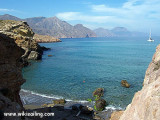
Le golfe de Mazarron est une large baie ouverte qui s'étend depuis le mont Cope jusqu'au cap Tinoso à 18,5 milles à l'ENE. Les rives en sont basses, mais les terres s'élèvent progressivement vers l'intérieur. Mazarron c'est 35 km de plages, de falaises et de petites criques. Attention ...
At N of Cape Tinoso, the Salitrona cove is protected by highlands. It can be anchored in one of the two small coves by 35 m of water and 1 mile of the lighthouse on a sandy bottom.
Hormigas islands located in the region of Murcia, 2MN and a half from the coast. Las Hormigas, formed by a chain of islets and rocky shoals, extends up to 3 miles NE of Cabo de Palos.
Islas Hormiga, the largest islet of this chain, lies 2.3 miles NE of the ...
Mount Cope is a rocky promontory, steep, reddish, 250 m high. It has a front 0.75 mile long between the points of Penon de Santa Maria in SW and Cerro de la Cruz NE. The first point forms the E end of Bardina Cove where there is a good anchorage well sheltered from E winds.Near ...
The rocky promontory of Las Aguilas separates the port of Poniente located at the W, the port of Aguilas proper located at E. The port of poniente is used only for the consruction and the beaching of the fishing boats. The depths are variable.The port of Aguilas lies between Negra ...


 canal 9


")
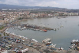
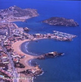
") Le nouveau port de Mazarron
Le nouveau port de Mazarron Il y a deux ports de Mazarron: le port de pêche Azohia et Puerto de Mazarron (37°3344, -1°1637) et le port de plaisance Puerto de Mazarron et Isla Plana (37°3382, -1°1535).
")