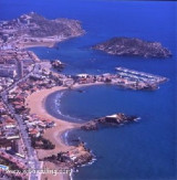
Mount Cope is a rocky promontory, steep, reddish, 250 m high. It has a front 0.75 mile long between the points of Penon de Santa Maria in SW and Cerro de la Cruz NE. The first point forms the E end of Bardina Cove where there is a good anchorage well sheltered from E winds.Near Cerro de la Cruz point is Cope's tower, surrounded by a few houses. It can be anchored by 13 to 15 m of water, at the N of the point and about 0.5 mile from the tower.
2019/06/7
Update
azerty
Le mont Cope est un promontoire rocheux, escarpé, de couleur rougeâtre, haut de 250 m. Il présente un front long de 0,75 mille entre les pointes del Penon de Santa Maria au SW et del Cerro de la Cruz au NE. La première pointe forme l'extrémité E de l'anse Bardina où l'on trouve un bon mouillage bien abrité des vents d'E. Près de la pointe del Cerro de la Cruz, on voit la tour de Cope, environnée de quelques maisons. On peut mouiller par 13 à 15 m d'eau, au N de la pointe et à 0,5 mille environ de la tour.
2019/06/7
Update
azerty
Share your comments or photos on "Cala Bardina (Murcia)"
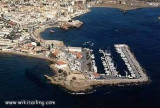
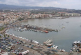
The rocky promontory of Las Aguilas separates the port of Poniente located at the W, the port of Aguilas proper located at E. The port of poniente is used only for the consruction and the beaching of the fishing boats. The depths are variable.The port of Aguilas lies between Negra ...
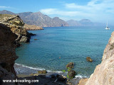
Le golfe de Mazarron est une large baie ouverte qui s'étend depuis le mont Cope jusqu'au cap Tinoso à 18,5 milles à l'ENE. Les rives en sont basses, mais les terres s'élèvent progressivement vers l'intérieur. Mazarron c'est 35 km de plages, de falaises et de petites criques. Attention ...
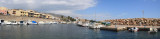
Il y a deux ports de Mazarron: le port de pêche Azohia et Puerto de Mazarron (37°3344, -1°1637) et le port de plaisance Puerto de Mazarron et Isla Plana (37°3382, -1°1535). 250 pl. (<20m) T. 968.594.520 F. 968.595.253
At N of Cape Tinoso, the Salitrona cove is protected by highlands. It can be anchored in one of the two small coves by 35 m of water and 1 mile of the lighthouse on a sandy bottom.
The port extends between two jetties. The pier of the E (Levante) starts near the San Jacinto factory. Pier W (Poniente) starts from a point of the coast located 500 m SW of the root of the pier of the E. The width of the entrance is 170 m and the depth of 14 m on sandy bottom, decreasing ...


")
 Mount Cope is a rocky promontory, steep, reddish, 250 m high. It has a front 0.75 mile long between the points of Penon de Santa Maria in SW and Cerro de la Cruz NE.
 Le mont Cope est un promontoire rocheux, escarpé, de couleur rougeâtre, haut de 250 m. Il présente un front long de 0,75 mille entre les pointes del Penon de Santa Maria au SW et del Cerro de la Cruz au NE.