Hormigas islands located in the region of Murcia, 2MN and a half from the coast. Las Hormigas, formed by a chain of islets and rocky shoals, extends up to 3 miles NE of Cabo de Palos.
Islas Hormiga, the largest islet of this chain, lies 2.3 miles NE of the ...
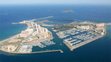
This yacht club forms an island 100 meters from the beach, S Los Urrutias town and SW Mar Menor. A bridge connects it to the mainland. It has an hexagonal shape that provides a protected lagoon inside.
T. 968 134438 F. 968 134438 Mail:
informacion@clubregatasmarmenor.com 280 ...
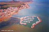
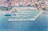
S of the Manga, strip of sand 22km long and 100-800 m wide, is the Port Tomas Maestre, along the Mar Menor.
Access to the marina from the Mediterranean, is through a channel of 1, 5 m with swing bridge (pairs every two hours during one quarter of an hour), which joins the sea ...
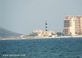
Punta del Estacio is located 7 miles NNW of Cabo de Palos. It is formed by the low and rocky SE extremity of a small peninsular which projects from the coast. A light is shown from a tower, 29m high, standing on the point.
A coast guard hut and several other buildings are ...
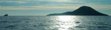
Isla Grosa, 95m high, lies 1.5 miles offshore, 3.7 miles NNE of Punta de Calnegre. This island is high, steep-sided, and flat-topped. A light is shown from a structure standing on the summit.
Anchorage, sheltered from E winds, can be obtained by vessels with local knowledge, ...
Located N Mar menor, the access is via a beaconed channel with about 2,20 m depth. Lo Paganis famous for medicinal mud baths and for saline of the Natural park of San Pedro.Tel: +34 968 186969Email: info@clubnauticolopagan.com357 b. (<14 m), 20 visit.


 canal 9, 16


 Port formed by two wharfs in the shape of "L", one from the beach and the second from the previous. The entrance is about 20 m wide.
 Port formé par 2 digues en forme de "L", l'une part de la plage et l'autre part de la première. L'entrée est large d'environ 20 m.
")