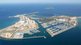
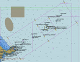
Punta del Estacio is located 7 miles NNW of Cabo de Palos. It is formed by the low and rocky SE extremity of a small peninsular which projects from the coast.
A light is shown from a tower, 29m high, standing on the point.
A coast guard hut and several other buildings are situated near the light tower. An extensive yacht harbor (Puerto des Tomas Maestre), protected by a breakwater, is situated close W of this point at the main entrance to Mar Menor.
2012/05/18
Update
Jojo
2012-05-18
Update
Jojo
La Pointe del Estacio se trouve à 7 MN au NNW de Cabo de Palos. C'est un ensemble de rochers bas à l'extrémité SE d'une petite péninsule.
Un feu haut de 29 m, s'élève à ce point.
Une cabane de garde-côtes et plusieurs autres bâtiments sont situés près du feu. Un port de plaisance (Puerto des Tomas Maestre) vaste, protégé par une digue, se trouve à l'W à proximité de ce point, à l'entrée principale de Mar Menor.
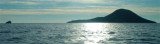
Hormigas islands located in the region of Murcia, 2MN and a half from the coast. Las Hormigas, formed by a chain of islets and rocky shoals, extends up to 3 miles NE of Cabo de Palos.
Islas Hormiga, the largest islet of this chain, lies 2.3 miles NE of the ...
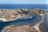
S of the Manga, strip of sand 22km long and 100-800 m wide, is the Port Tomas Maestre, along the Mar Menor.
Access to the marina from the Mediterranean, is through a channel of 1, 5 m with swing bridge (pairs every two hours during one quarter of an hour), which joins the sea ...
Isla Grosa, 95m high, lies 1.5 miles offshore, 3.7 miles NNE of Punta de Calnegre. This island is high, steep-sided, and flat-topped. A light is shown from a structure standing on the summit.
Anchorage, sheltered from E winds, can be obtained by vessels with local knowledge, ...
Punta de Calnegre (or De La Raja), a rocky point partly covered with sand, is located 2.3 miles NW of Cabo de Palos. A rocky hillock, 43m high, stands close W of it. Two marine farms, best seen on the chart, are located E of the point.
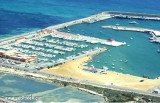
Located in Las Palmeras bay, in front of Ciervo island, this harbour is connected at it by an isthmus. T. 968 140 117F. 968 140 117M.5 club2mares@yahoo.es270 pl. (<17 m)Caution the harbour has'nt marking at night, so it should be avoided boarding.
Marina de Las Salinas is inside San Pedro del Pinatar harbour at SW.T/F. 630 422 126 - 968 182 880M. info@clubnauticovillasanpedro.com205 b. (<30 m)Depth 3,20 m to 30 m


")
 La Pointe del Estacio se trouve à 7 MN au NNW de Cabo de Palos. C'est un ensemble de rochers bas à l'extrémité SE d'une petite péninsule.