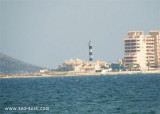
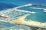
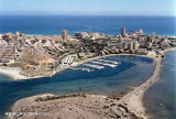
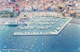
S of the Manga, strip of sand 22km long and 100-800 m wide, is the Port Tomas Maestre, along the Mar Menor.
Access to the marina from the Mediterranean, is through a channel of 1, 5 m with swing bridge (pairs every two hours during one quarter of an hour), which joins the sea Minor, realizing the unique communication between the two seas.
Please note access is dangerous in strong winds. Prevailing winds are: NE, SE.
T. +34 968 140816 Fax: +34 968 143600 Email: asopuerto@ncsa.es 1625 pl. (<30 m) of which 170 visit.
2019/06/7
Update
Jojo
Au S de la Manga, langue de sable de 22km de long sur 100 à 800 m de large, se trouve le port Tomas Maestre, en bordure de la Mar Menor.
L'accès à la marina depuis la Méditerranée, se fait par un chenal d'1,5 m avec pont tournant (toutes les deux heures paires pendant 1/4 d’heure), qui rejoint la mer Mineure, réalisant l'unique communication entre les deux mers.
Attention l'accès est dangereux par vents forts. Les vents dominants sont: NE, SE.
T. +34 968 140816 Fax: +34 968 143600 Email: asopuerto@ncsa.es 1625 pl. (<30 m) dont 170 visit.
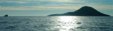
Hormigas islands located in the region of Murcia, 2MN and a half from the coast. Las Hormigas, formed by a chain of islets and rocky shoals, extends up to 3 miles NE of Cabo de Palos.
Islas Hormiga, the largest islet of this chain, lies 2.3 miles NE of the ...
Punta del Estacio is located 7 miles NNW of Cabo de Palos. It is formed by the low and rocky SE extremity of a small peninsular which projects from the coast. A light is shown from a tower, 29m high, standing on the point.
A coast guard hut and several other buildings are ...
Isla Grosa, 95m high, lies 1.5 miles offshore, 3.7 miles NNE of Punta de Calnegre. This island is high, steep-sided, and flat-topped. A light is shown from a structure standing on the summit.
Anchorage, sheltered from E winds, can be obtained by vessels with local knowledge, ...
Marina de Las Salinas is inside San Pedro del Pinatar harbour at SW.T/F. 630 422 126 - 968 182 880M. info@clubnauticovillasanpedro.com205 b. (<30 m)Depth 3,20 m to 30 m
Located in Las Palmeras bay, in front of Ciervo island, this harbour is connected at it by an isthmus. T. 968 140 117F. 968 140 117M.5 club2mares@yahoo.es270 pl. (<17 m)Caution the harbour has'nt marking at night, so it should be avoided boarding.
Located N Mar menor, the access is via a beaconed channel with about 2,20 m depth. Lo Paganis famous for medicinal mud baths and for saline of the Natural park of San Pedro.Tel: +34 968 186969Email: info@clubnauticolopagan.com357 b. (<14 m), 20 visit.


 canal 9


")
")
 S of the Manga, strip of sand 22km long and 100-800 m wide, is the Port Tomas Maestre, along the Mar Menor.
 Au S de la Manga, langue de sable de 22km de long sur 100 à 800 m de large, se trouve le port Tomas Maestre, en bordure de la Mar Menor.