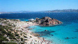
Palau harbour is in front of Maddalena archipelago. Once a small farming village, Palau is a modern city which serves mainly city permission to U.S. soldiers stationed in I. San Stefano and La Maddalena Ferry Port. The entrance is easy and there is no danger, but constant attention to passages boats carrying passengers for Maddalena, to barges for excursions and general traffic during the summer.Port sheltered from all winds, except for strong wind NE.
Municipal harbor with pontoons offering some berths for boaters.
T./Fax: +39.0789.708435
M. portopalau@tiscali.it
380 b. incl. 30 visit. (<18 m)
Depth 2 à 4m
The marina has been awarded a Blue Flag.
2019/07/29
Update
Joëlle
Le port de Palau se trouve en face de l'archipel de la Maddalena .
Autrefois petit village de cultivateurs, Palau est une ville moderne qui sert essentiellement de ville de permission aux soldats americains postés sur I. San Stefano et de port Ferry pour la Maddalena.
L'entrée est facile et il n'y a pas de danger, mais attention aux passages continuels des bateaux de transport de passagers pour la Maddalena, aux chalands pour les excursions et au trafic en général pendant la période estivale.
Port abrité de tous les vents, sauf par fort vent NE.
Port communal avec des pontons flottants proposant quelques places aux plaisanciers.
T./Fax: +39.0789.708435
M. portopalau@tiscali.it
380 places dont 30 visit. (<18 m)
Profondeur 2 à 4m
2012/11/23
Update
Joëlle
Porto di Palau si trova davanti l'arcipelago della Maddalena.
Palau era un piccolo villaggio agricolo, oggi Palau è una città moderna che serve principalmente dicittà di permesso ai soldati americani di stanza su I. San Stefano e di traghetto porto per La Maddalena.
L'ingresso è semplice e non c'è pericolo, ma bisogna fare una costante attenzione alle imbarcazioni che trasportano i passeggeri per la Maddalena, di passaggi di chiatte per le escursioni e dal traffico in generale durante l'estate.
Porto al riparo da tutti i venti tranne che da vento forte NE.
Porto comunale con pontili che offrono alcuni posti barca per i diportisti.
It is the largest island of the archipelago composed of sixty islets and 7 major islands, in the NE end tip of Sardinia. It is mountainous and arid. This is the only inhabited island thoroughly. It is connected by a bridge to Caprera island where are the house and the tomb of Garibaldi. ...
Gulf of Arzachena (Arsachena), located between Punta Saline and Tre Monti Cape, is a high inlet whose banks are lined with shoals. S tip, Arzachena, W of the entrance, a beacon consists of an iron post with a sheer spherical white marks a rock particularly ...
La tourelle Pecorella marque l'entrée de ce golfe qui s'enfonce à plus de 4 M dans les terres. Celle de Chiapino qui était plus au S est démolie. Il faut donc remonter suffisamment vers le N pour ne pas risquer d'en toucher les restes. En piquant vers l'W, la balise noire délimite ...
SW of Corsica offers some of the most beautiful anchorages. As you get closer to Bonifacio be carreful with the weather forecast as the NW wind can be very strong.
The range of the tide in this area is negligible. There are no regular currents along the coasts of Corse, ...
A little less than 1 NM to the E of Ventotene island, there is the island of Santo Stefano, the smallest of the archipelago.
This island is occupied by the army. Currently there is a NATO base on the island of Santo Stefano. The NATO base housed an Italian Marine barracks ...


 canal 9, 16


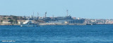
") Commercial harbour
Commercial harbour")
")
 Palau harbour is in front of Maddalena archipelago.
 Le port de Palau se trouve en face de l'archipel de la Maddalena .
 Porto di Palau si trova davanti l'arcipelago della Maddalena.
") Porto Turistico
Porto Turistico") Travel lift
Travel lift")
") Slip
Slip") Petrol pump
Petrol pump