Isola Santo Stefano (Arch. Maddalena)

Isola Santo Stefano (Arch. Maddalena)

To precisely geolocate this site. Update if necessary.

Localisation

Characteristics

Coast

Description

A little less than 1 NM to the E of Ventotene island, there is the island of Santo Stefano, the smallest of the archipelago.

This island is occupied by the army. Currently there is a NATO base on the island of Santo Stefano. The NATO base housed an Italian Marine barracks and served as the home port for several US Navy submarine tenders over the years, ending with the departure of the USS Emory S. Land, which set sail for its new home port of Bremerton, Washington. The base closes by spring 2008, ending the US presence there as the US reprioritizes its worldwide presence. 

The only authorized anchorage is S of the island, to Cala di Villamarina.

The NW coast is overwhelmed by shoals: a white pyramid shows the dangers of the W island Roma (La Paura); a white buoy tags La Paura shoal and a buoy and a black and white tags shoal Chiesa.
The passage between Chiesa island and the S. Stefano island connects the harbor of S. Stefano with the harbor of La Maddalena. It is 100 m wide and minimum depth is 3.2 m. Its S side is marked by a red beacon and a buoy about 0.2 NM to WNW.
The N side of the passage is marked by the flagship S end of the dam on the Chiesa island and a W buoy.
2013/03/12
Update
Joëlle
Isola Santo Stefano (Arch. Maddalena)
2013-03-12
Update
Joëlle
A moins d'1 MN à l'E de l'île de Ventotene, se trouve la plus petite île de l'archipel de la Maddalena.

Cette île est occupée par l'armée. Actuellement, il y a une base de l'OTAN sur l'île de Santo Stefano. La base de l'OTAN occupe une caserne de Marine italienne et a été le port d'attache de nombreux sous-marins de la marine des Etats Unis jusqu'à leur départ pour leur nouveau port d'attache de Bremerton à Washington. La base a été fermée au printemps 2008, mettant fin à la présence américaine sur l'île car les américains réorganisent leur présence mondiale.

Le seul point d'ancrage autorisé se trouve au S de l'île, à la Cala di Villamarina.

La côte NW est débordée sur toute son étendue par des hauts-fonds: une pyramide blanche marque les dangers à l'W de 'îlot Roma (La Paura); une bouée blanche balise le haut-fond La Paura et une bouée noire et blanche le haut-fond Chiesa.
Le passage entre l'île Chiesa et l'île S. Stefano fait communiquer la rade de S. Stefano avec la rade de la Maddalena. Il est large de 100 m et sa profondeur minimale est de 3,2 m. Son côté S est marqué par une balise lumineuse rouge et une bouée mouillée à 0,2 MN environ à l'WNW.
Le côté N du passage est marqué par le phare de l'extrémité S de la digue de l'île de la Chiesa et une bouée mouillée à l'W.
2013/03/12
Update
Joëlle
Isola Santo Stefano (Arch. Maddalena)
Naval base. View from South.
2013-03-12
Update
Joëlle
A poco meno di un miglio ad Est dell’isola di Ventotene, vi è l’isola di Santo Stefano, la più piccola dell’arcipelago.

L'isola è occupata dai militari. Attualmente, vi è una base NATO sull'isola di Santo Stefano. La base NATO occupa una caserma della Marina Militare Italiana ed è stato il porto di molti sottomarini della Marina degli Stati Uniti fino a quando lasciano il loro porto di partenza per la nuova Bremerton Washington. La base è stata chiusa nella primavera del 2008, ponendo fine alla presenza americana sull'isola perchè Gli americani riorganizzano la loro presenza a livello mondiale.

L'unica ancora è autorizzata a S dell'isola, alla Cala di Villamarina.

La costa NW è sopraffatta dai banchi su tutta la sua area: un bianco piramide indica i pericoli all'W dall'isolotto Roma (La Paura); una boa bianca indica la secca La Paura e una boa bianca e nera indica la secca Chiesa.
Il passaggio tra l'isola Chiesa e l'isola S. Stefano collega il porto di S. Stefano colla rada della Maddalena. Si trova a 100 m di larghezza e la profondità minima è di 3,2 m. Il suo lato S è caratterizzato da un faro rosso e una boa a circa 0,2 MN all'WNW.
Il lato N del passaggio è segnato dallo faro dell'estremità S della diga sull'isola della Chiesa e una boa all'W.
2013/03/12
Update
Joëlle
Ebook

Sardegna North East

  • 156 sites
  • 349 photos
  • publication date: 11 Jul 2023
  • .pdf file size: 66 Mb
Ebook

Sardegna

  • 444 sites
  • 1069 photos
  • publication date: 11 Jul 2023
  • .pdf file size: 243 Mb
Share your comments or photos on "Isola Santo Stefano (Arch. Maddalena)"

Sites around Isola Santo Stefano (Arch. Maddalena)

Flying distances - Direct line

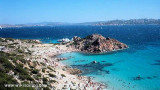
Isola La Maddalena (Arcipelago della Maddalena)

2.2nm
357°
It is the largest island of the archipelago composed of sixty islets and 7 major islands, in the NE end tip of Sardinia. It is mountainous and arid. This is the only inhabited island thoroughly.
It is connected by a bridge to Caprera island where are the house and the tomb of Garibaldi. ...
26 Nov 12
Joëlle

Golfo Di Arzachena (Sardegna)

4.4nm
154°
Gulf of Arzachena (Arsachena), located between Punta Saline and Tre Monti Cape, is a high inlet whose banks are lined with shoals.
S tip, Arzachena, W of the entrance, a beacon consists of an iron post with a sheer spherical white marks a rock particularly ...
8 Sep 12
Joëlle

Golfe de Porto Vecchio

24nm
350°
La tourelle Pecorella marque l'entrée de ce golfe qui s'enfonce à plus de 4 M dans les terres. Celle de Chiapino qui était plus au S est démolie. Il faut donc remonter suffisamment vers le N pour ne pas risquer d'en toucher les restes.
En piquant vers l'W, la balise noire délimite ...
10 Jul 20
azerty

Senetose - Tizzano

34nm
307°
SW of Corsica offers some of the most beautiful anchorages. As you get closer to Bonifacio be carreful with the weather forecast as the NW  wind can be very strong.

The range of the tide in this area is negligible. There are no regular currents along the coasts of Corse, ...
15 May 12
dd

Isola Santa Maria (Arcipelago Maddalena)

6nm
349°
Santa Maria is an island north of the chaplet Razzoli, Budelli and Santa Maria. It has an area of 2 km and a perimeter of ​​about 10 km.

You can anchor in the NW in Cala Muro or SE  in Cala Santa Maria.Santa Maria is separated of Razzoli by the very narrow pass degli ...
25 Nov 12
Joëlle