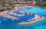
Porto di Golfo Aranci lies at the E head of the gulf and is mainly used by ferries. The harbor consists of two basins, divided by moles.
The most remarkable buildings are the post yellowish, the rooting of the median, and E of the village, a house yellow and blue with two floors.
The harbor consists of a pier rooted on an embankment that connects it to the bank. S of the wharf pier also takes root on the median. SE side of the pier is lined with a quay along which there is 6-7 feet of water. N quay a pier angled houses a small harbor for boats.
T. (+39) 78 94 68 80
M. goloaranci@guardiacostiera.it
100 b. (<8 m)
Draft: 0,5 à 5 m
Depth: 7.7m in the S basin and 5.3 to 7.2m in the N basin.
A small fishing and yacht harbor lie close N of the commercial quay.
2012/09/28
Update
Joëlle
2012-09-28
Update
Joëlle
Le petit port de Golfo di Aranci, situé dans la partie E du golfe, est principalement utilisé par les Ferries. Le port a deux bassins divisés par des môles.
Les édifices les plus remarquables sont la poste, de couleur jaunâtre, à l'enracinement du terre-plein et, à l'E du village, une maison jaune et bleue à deux étages.
Le port se compose d'un môle qui prend racine sur un terre-plein qui le relie à la rive. Au S du môle un appontement prend également racine sur le terre-plein. La face SE du môle est bordée d'un quai le long duquel on trouve 6 à 7 m d'eau. Au N du terre-plein, une jetée coudée abrite un petit port pour embarcations.
T. (+39) 78 94 68 80
M. goloaranci@guardiacostiera.it
100 pl. (<8 m)
TE: 0,5 à 5 m
profondeur: 7,7 m dans le S du bassin et 5,3 à 7,2 m dans le bassin N
Un petit port de pêche et de plaisance se trouve au N du quai commercial.
2012/09/28
Update
Joëlle
2012-09-28
Update
Joëlle
Il piccolo porto di Golfo Aranci , situato E nel Golfo viene utilizzato principalmente da Ferries. Il porto è dotata di due vasche divise da pilastri.
Gli edifici più notevoli sono il post giallo, allo radicamento della mediana, ed all'E del villaggio, una casa gialla e blu di due piani.
Il porto è costituito da un molo radicato su un terrapieno che lo collega alla banca. Al Sud dello molo uno pontile prene anche radice nella mediana. Lato SE del molo è fiancheggiata da una banchina lungo la quale ci sono 6-7 m d'acqua. N di terrapieno, una jetty ad angolo che fa uno piccolo porto per le barche.
Tavolara island is a limestone massif 6 kilometres long and 500 m wide, and 565 m high.The overhanging cliffs make it inaccessible, with the exception of a bay and a beach that is located at each end of the island, Spalmatore di Fuori northeast (military zone) and Spalmatore di Terra ...
Degli Aranci gulf is is bounded, on the N, by the peninsula of which Capo Figari is the E extremity.This gulf is sheltered from NE and NW winds. Strong SE winds send in a heavy sea and storms from the N and E cause a considerable swell in the gulf. During offshore winds, which are ...
This gulf is S Cugnana gulf, S cala della Volpe. It is entered between Punta della Volpe and Punta Canigione.This gulf is the most protected area of the coast. Although the anchorage is prohibited in the Gulf because of submarine telegraph cables, many boaters anchor in this ...
Gulf of Arzachena (Arsachena), located between Punta Saline and Tre Monti Cape, is a high inlet whose banks are lined with shoals. S tip, Arzachena, W of the entrance, a beacon consists of an iron post with a sheer spherical white marks a rock particularly ...
It is the largest island of the archipelago composed of sixty islets and 7 major islands, in the NE end tip of Sardinia. It is mountainous and arid. This is the only inhabited island thoroughly. It is connected by a bridge to Caprera island where are the house and the tomb of Garibaldi. ...
Caddinas bay is a small private port located in the bay of the same name, about the middle of the Gulf Aranci.
It is also a beautiful sandy beach.Avoid entering the port by Sirocco wind.
An access channel to the port is bounded by four green buoys to Starboard and red to ...


 canal 9
 fontaine


 Porto di Golfo Aranci lies at the E head of the gulf and is mainly used by ferries. The harbor consists of two basins, divided by moles.
")
 Le petit port de Golfo di Aranci, situé dans la partie E du golfe, est principalement utilisé par les Ferries. Le port a deux bassins divisés par des môles.
")
 Il piccolo porto di Golfo Aranci , situato E nel Golfo viene utilizzato principalmente da Ferries. Il porto è dotata di due vasche divise da pilastri.
")