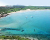
Porto S. Nicolo dell'Argentiera is a small cove NE of the cape, where we see an isolated church on a hill and facilities for operating mine.
Well protected from N NE winds. Un small jetty can disembark by 0.50 to 2 m of water. There are about 250 berths, but there is no service.
You can anchor in the middle of the cove by 10 to 12 m of water.
Attention to the rock located 200 m from the Port tip entering.
2012/11/21
Update
Joëlle
Port S. Nicolo dell'Argentiera est une petite anse située au NE du cap, où l'on voit une église isolée sur une éminence et les installations d'une mine en exploitation. Bien protégée des vents forts N NE. Un petit appontement permet de débarquer par 0,50 à 2 m d'eau. Il y a environ 250 places, mais il n'y a aucun service.
On peut mouiller au milieu de l'anse par 10 à 12 m d'eau.
Attention au rocher situé à 200 m de la pointe bâbord en entrant
2012/11/21
Update
Joëlle
Porto S. Nicolo dell'Argentiera è una piccola baia a NE del capo, dove si vede una chiesa isolate su una collina e le strtture di una miniera di esercizio. Ben protetta dei venti N NE. Esiste un piccolo pontile dov'è possibile attraccare in 0,50 a 2 m di acqua. Ci sono circa 250 posti barca, ma non vi è alcun servizio.
È possibile ancorare nel mezzo della cala da 10 a 12 m di acqua. Attenzione alla roccia che si trova a 200 m dalla punta a Babordo in entrando.
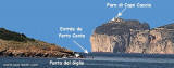
The park begins at Capo Galera to continue toward the gulf of Porto Conte that is protected by two promontories, Punta Giglio and Capo Caccia-Monte Timidone. The marine protected area embraces the stretch of sea to the north-west of Punta Cristallo.Almost all of the park consists ...
Porto Conte is a natural bay between Punta del Giglio and Caccia cape.Along E shore of the bay, on a projecting point, we see Porto Conte village, with the tower Nuova, which is backed by a turret with a light.You can anchor anywhere. The bay offers shelter from all winds. Mount ...
Rada di Alghero is entered between S, the town of Alghero and N, capo Galera.The E shore of this bay is low and sandy, and the W shore is hilly and rocky. An undulating coastal plain, partly under cultivation, lies immediately inland of the head of this bay.This bay is open to ...
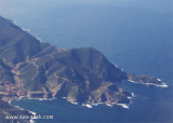
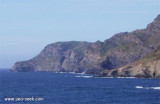
Argentiera cape, 221 m high, can be easily recognized with the miniera dell'Argentiera stands close E of the cape.From Capo dell’ Argentiera to Capo del Falcone, 14 NM, the coast is high, rocky, and inaccessible. It has a whitish color for about 3 miles to the SSW of Capo del Falcone.
Porto Ferru (or Porto Ferro) is a deep inlet which each entry points carries a tower. S tower Bandine Sale half-ruined little apparent, N Negra tower clearly visible and a third tower, torre Bianca. The sandy beach stretches about 2 km.


 quay
quay


 Porto S. Nicolo dell'Argentiera is a small cove NE of the cape, where we see an isolated church on a hill and facilities for operating mine.
 Port S. Nicolo dell'Argentiera est une petite anse située au NE du cap, où l'on voit une église isolée sur une éminence et les installations d'une mine en exploitation.
 Porto S. Nicolo dell'Argentiera è una piccola baia a NE del capo, dove si vede una chiesa isolate su una collina e le strtture di una miniera di esercizio.