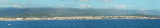
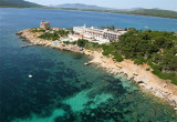
Porto Ferru (or Porto Ferro) is a deep inlet which each entry points carries a tower. S tower Bandine Sale half-ruined little apparent, N Negra tower clearly visible and a third tower, torre Bianca. The sandy beach stretches about 2 km.
This cove is popular with surfers and windsurfers.
You can anchor by 6 m on sandy bottom.
2012/11/20
Update
Joëlle
Porto Ferru (ou Porto Ferro) est une anse profonde dont les points d'entrée portent chacun une tour. Au S la tour Bandine Sale à demi-ruinée, peu apparente, au N la tour Negra bien visible et une troisième tour, torre Bianca. La plage de sable s'étend sur environ 2 km.
Cette anse est fréquentée par les surfeurs et windsurfeurs.
On peut mouiller par 6 m sur fond de sable.
2012/11/20
Update
Joëlle
Porto Ferru (o Porto Ferro) è una profonda insenatura dove i punti portano ciascuno una torre. A S la torre Bandine Sale mezza in rovina poco apparente, a N torre Negra ben visibile e una terza torre, torre Bianca. La spiaggia di sabbia si estende per circa 2 km.
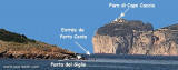
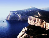
The park begins at Capo Galera to continue toward the gulf of Porto Conte that is protected by two promontories, Punta Giglio and Capo Caccia-Monte Timidone. The marine protected area embraces the stretch of sea to the north-west of Punta Cristallo.Almost all of the park consists ...
Porto Conte is a natural bay between Punta del Giglio and Caccia cape.Along E shore of the bay, on a projecting point, we see Porto Conte village, with the tower Nuova, which is backed by a turret with a light.You can anchor anywhere. The bay offers shelter from all winds. Mount ...
Rada di Alghero is entered between S, the town of Alghero and N, capo Galera.The E shore of this bay is low and sandy, and the W shore is hilly and rocky. An undulating coastal plain, partly under cultivation, lies immediately inland of the head of this bay.This bay is open to ...
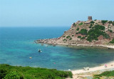
Nuova tower, 1,5 NM of Punta del Giglio, is a big tower overlooking the sea, near the lighthouse. Built in 1572, it has a diameter of 18 m over 13 m high.


 Porto Ferru (or Porto Ferro) is a deep inlet which each entry points carries a tower. S tower Bandine Sale half-ruined little apparent, N Negra tower clearly visible and a third tower, torre Bianca.
 Porto Ferru (ou Porto Ferro) est une anse profonde dont les points d'entrée portent chacun une tour. Au S la tour Bandine Sale à demi-ruinée, peu apparente, au N la tour Negra bien visible et une troisième tour, torre Bianca.
 Porto Ferru (o Porto Ferro) è una profonda insenatura dove i punti portano ciascuno una torre. A S la torre Bandine Sale mezza in rovina poco apparente, a N torre Negra ben visibile e una terza torre, torre Bianca.
")
") Bianca tower
Bianca tower") Bandine Sale tower
Bandine Sale tower") Negra tower
Negra tower")