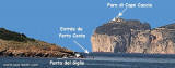
The park begins at Capo Galera to continue toward the gulf of Porto Conte that is protected by two promontories, Punta Giglio and Capo Caccia-Monte Timidone. The marine protected area embraces the stretch of sea to the north-west of Punta Cristallo.Almost all of the park consists ...
Porto Conte is a natural bay between Punta del Giglio and Caccia cape.Along E shore of the bay, on a projecting point, we see Porto Conte village, with the tower Nuova, which is backed by a turret with a light.You can anchor anywhere. The bay offers shelter from all winds. Mount ...
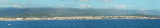
Rada di Alghero is entered between S, the town of Alghero and N, capo Galera.The E shore of this bay is low and sandy, and the W shore is hilly and rocky. An undulating coastal plain, partly under cultivation, lies immediately inland of the head of this bay.This bay is open to ...
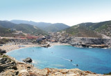
Porto S. Nicolo dell'Argentiera is a small cove NE of the cape, where we see an isolated church on a hill and facilities for operating mine. Well protected from N NE winds. Un small jetty can disembark by 0.50 to 2 m of water. There are about 250 berths, but there is no service.
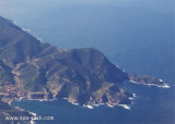
Argentiera cape, 221 m high, can be easily recognized with the miniera dell'Argentiera stands close E of the cape.From Capo dell’ Argentiera to Capo del Falcone, 14 NM, the coast is high, rocky, and inaccessible. It has a whitish color for about 3 miles to the SSW of Capo del Falcone.


 Capo Mannu (San Nicolo), 3 NM N of Porto S Nicolo,is 150 m high.
 Le cap Mannu (San Nicolo), à 3MN au N de Porto San Nicolo, est haut de 150m.
 Capo Mannu (San Nicolo), è a 3 MN da porto San Nicolo. E'150 m alto.
")
")