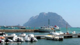
Tavolara island is a limestone massif 6 kilometres long and 500 m wide, and 565 m high.The overhanging cliffs make it inaccessible, with the exception of a bay and a beach that is located at each end of the island, Spalmatore di Fuori northeast (military zone) and Spalmatore di Terra ...
Degli Aranci gulf is is bounded, on the N, by the peninsula of which Capo Figari is the E extremity.This gulf is sheltered from NE and NW winds. Strong SE winds send in a heavy sea and storms from the N and E cause a considerable swell in the gulf. During offshore winds, which are ...
This gulf is S Cugnana gulf, S cala della Volpe. It is entered between Punta della Volpe and Punta Canigione.This gulf is the most protected area of the coast. Although the anchorage is prohibited in the Gulf because of submarine telegraph cables, many boaters anchor in this ...
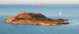
Isola Molara, private island, S Tavolara island, 158m high, is undulating and partially cultivated.The coasts are high and rocky at E (Punta Levante et Punta di Sirocco), they are more practicable with the few beaches and coves located in NW (Cala Cala Chiesa e Spagnola).We see a ...
S porto Istana is a small private marina, near a beautiful sandy beach. T. +39 0789 36176 F. +39 0789 36680 M. info@spurlatta.it 137 b. incl. 14 visit. (<11 m)


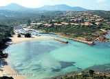
 Opposite the island Tavolara, this bay is bordered by a beautiful white sand beach and is partly sheltered by the island of Tavolara.
 Située en face de l'île Tavolara, cette baie est bordée d'une belle plage de sable blanc et est en partie abritée par l'île de Tavolara.
 Di fronte all'isola di Tavolara, questa baia è circondata da una bellissima spiaggia di sabbia bianco ed è in parte protetta dall'isola di Tavolara.
")
")
")
")