In the gulf we anchor in 15 m of water to 0,4 NM, SSE of Portisco islet.
2012/09/20
Update
Joëlle
Situé dans la rade naturelle de Cugnana, qui s'ouvre entre Marina di Portisco e Punta Nuraghe, au SW. Des appontements en maçonnerie se trouvent au fond du golfe.
La profondeur est de 3 à 5 m. Attention au S de la rade les fonds remontent.
Dans le golfe on mouille par 15 m d'eau à 0,4 M au SSE de l'îlot Portisco.
2012/09/20
Update
Joëlle
è situato nella rada naturale di Cugnano che si apre tra la Marina di Portisco e Punta Nuraghe, al SW. Dei pontile gallegianti si trovano nell' fondo del golfo.
I fondali sono da 3 a 5 m. Attenzione al S della rada i fondali sono bassi.
Gulf of Arzachena (Arsachena), located between Punta Saline and Tre Monti Cape, is a high inlet whose banks are lined with shoals. S tip, Arzachena, W of the entrance, a beacon consists of an iron post with a sheer spherical white marks a rock particularly ...
Tavolara island is a limestone massif 6 kilometres long and 500 m wide, and 565 m high.The overhanging cliffs make it inaccessible, with the exception of a bay and a beach that is located at each end of the island, Spalmatore di Fuori northeast (military zone) and Spalmatore di Terra ...
It is the largest island of the archipelago composed of sixty islets and 7 major islands, in the NE end tip of Sardinia. It is mountainous and arid. This is the only inhabited island thoroughly. It is connected by a bridge to Caprera island where are the house and the tomb of Garibaldi. ...
Degli Aranci gulf is is bounded, on the N, by the peninsula of which Capo Figari is the E extremity.This gulf is sheltered from NE and NW winds. Strong SE winds send in a heavy sea and storms from the N and E cause a considerable swell in the gulf. During offshore winds, which are ...
This gulf is S Cugnana gulf, S cala della Volpe. It is entered between Punta della Volpe and Punta Canigione.This gulf is the most protected area of the coast. Although the anchorage is prohibited in the Gulf because of submarine telegraph cables, many boaters anchor in this ...
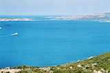
Cugnana gulf is a natural bay that is entered between Marina di Portisco and Nuraghe point. Internally there are two landing piers with privately managed (Porto Asfodeli and Marina di Cugnana).
To the south of the bay, the depth of weed and mud, is low (0,5 m) and go down toward ...


 Located in the natural harbor of Cugnana, which opens between Marina di Portisco and SW Punta Nuraghe. Masonry wharves are at the bottom of the gulf.
 Situé dans la rade naturelle de Cugnana, qui s'ouvre entre Marina di Portisco e Punta Nuraghe, au SW. Des appontements en maçonnerie se trouvent au fond du golfe.
 è situato nella rada naturale di Cugnano che si apre tra la Marina di Portisco e Punta Nuraghe, al SW. Dei pontile gallegianti si trovano nell' fondo del golfo.
")
")