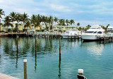
With easy access to the Atlantic Ocean and the Florida Bay, the sheltered harbor offers many amenities. Just offshore of the complex you can enjoy flyfishing.Area attractions provide a multitude of alternative entertainment such as, arts and crafts, boutiques with plenty of shopping and a very wide variety of restaurants to choose from.
Avec un accès facile à l'Ocean Atlantique et la baie de Floride, le port bien protégé offre de nombreuses infrastructures. Juste à côté du complexe vous pouvez pratiquer la pêche à la mouche. Les attractions des environs offrent une multitude de spectacles alternatifs tels que, les arts et l'artisanat, des boutiques avec beaucoup de commerces et d'une très grande variété de restaurants à choisir.
Long Key was called Cayo Vivora (Rattlesnake Key) by early Spanish explorers, a reference to the shape of the island, which resembles a snake with its jaws open, rather than to its denizens. In the early 20th century, Long Key was the site of a luxurious fishing resort that ...
The island lies to the southwest of Upper Matecumbe Key, and to the northeast of Craig Key. All of the key is within the Village of Islamorada as of November 4, 1997, when it was incorporated. This key is the site of a number of Indian mounds and middens, most of which were ...
Located on the southwestern reaches of charted Cowpens Anchorage. west of Plantation Key Yacht Harbor. Cowpens Anchorage comprises the southeasterly section of Cotton Key Basin and borders on Plantation Key.Minimum depth: 5-feet Open to the NW and N winds.
Marina is located at the W end of Plantation Key, just before Islamorada village. Plantation Yacht Harbor lies off the Florida Straits. Between ICW markers 78 and 78A. It will bear approximately 150°. Look for red and white lighthouse at the end of the breakwater. Reservations ...
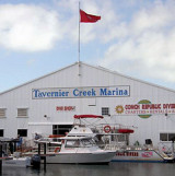
Whether you are fishing, cruising, or diving, we are most conveniently located on Tavernier Creek, with easy access to the Atlantic Ocean and Florida Bay.On the Bayside, Flashing Green # 71 On the Oceanside, Black & White flashing buoy.Tel: 305-852-5854 Fax:305-852-7425 Email: ...
The first underwater park in the U.S., John Pennekamp Coral Reef State Park encompasses approximately 70 nautical square miles. It is the coral reefs and their associated marine life that bring most visitors to the park. Many enjoy the view of the reef from a glass-bottom ...


 With easy access to the Atlantic Ocean and the Florida Bay, the sheltered harbor offers many amenities. Just offshore of the complex you can enjoy flyfishing.Area attractions provide a multitude of alternative entertainment such as, arts and crafts, boutiques with plenty of shopping and a very wide variety of restaurants to choose from.
 ")
 Avec un accès facile à l'Ocean Atlantique et la baie de Floride, le port bien protégé offre de nombreuses infrastructures.