Otok Hvar

Otok Hvar

To precisely geolocate this site. Update if necessary.

Localisation

Characteristics

Island / Atoll

Description

Otok Hvar
Otok Hvar
2011-04-03
Update
Jojo
Hvar (68 km long) is a part of the central Dalmatian archipelago and is located in an east-west direction, perpendicular to the coast. These islands are so called "Group of Hvar.
The island of Hvar is known since ancient times for its strategic position and water. It was settled in the fourth century BC. BC by Greeks from Paros (Paros or just Hvar Pharos lighthouse). It was later occupied by Romans, Slavs and Venetians, whose influence is still visible.
The situation of the island is such that it is practically on all routes of the Adriatic sea.
In the middle of the island of Hvar, a vast mountainous ranges, with the summit of Saint Nicolas (628 meters) north is the fertile Velo Polje plain. The north coast of the island, with the large bay of Stari Grad and with a string of bays, is much more diverse than the south coast and provides good anchorage for yachts.
The island of Hvar is famous for its pleasant Mediterranean climate.

The main places (all on the coast of the island) are: the town of Hvar, Stari Grad, Jelsa and Sucuraj Vrboska.

The offshore islands of Hvar, the Plakeni and O. Scedro, have also nice anchorages.

2011/05/30
Update
Jojo
Hvar (68 km de long) est une partie de l'archipel de Dalmatie centrale et se trouve dans une direction est-ouest, perpendiculairement à la côte. Ces îles sont ainsi appelés "Le Groupe de Hvar".

L'île de Hvar est connue dès l'Antiquité de par sa position stratégique et nautique. Elle fut colonisée au IVème siècle av. JC par les Grecs de Paros (Hvar vient de Paros ou Pharos, phare). Elle fut ensuite occupée par les Romains, les Slaves et les Vénitiens, dont l'influence est encore visible.

La situation de l' île est telle qu'elle se trouve pratiquement sur toutes les routes marines de l'Adriatique. 

Au milieu de l' île de Hvar, une partie montagneuse vaste s'étend, avec le sommet de Saint Nicolas (628 mètres) ; au nord se trouve la plaine fertile Velo Polje. La côte nord de l' île, avec la grande baie de Stari Grad et avec un chapelet de baies, est beaucoup plus diversifié que la côte sud et offre de bons mouillages aux bateaux de plaisance.

L'île de Hvar est célèbre pour son agréable climat méditerranéen.

Les principaux lieux (tous sur la côte de l'île) sont: la ville de Hvar, Stari Grad, Jelsa, Sucuraj et Vrboska.

Les îles au large de Hvar, les Plakeni et O. Scedro, ont de jolis mouillages.

2011/05/30
Update
Jojo
Ebook

Splitsko-dalmatinska županija (Split-Dalmatia Coun

  • 155 sites
  • 295 photos
  • publication date: 6 Jul 2023
  • .pdf file size: 97 Mb
Ebook

Dalmacija (Dalmatie)

  • 542 sites
  • 910 photos
  • publication date: 9 Jul 2023
  • .pdf file size: 302 Mb
Share your comments or photos on "Otok Hvar"

Sites around Otok Hvar

Flying distances - Direct line

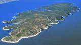
Starogradski Zaljev Hvar

8.6nm
288°
Starogradski is a large deep bay, open to the NW, which houses the city and the port of Stari Grad on its SE end.
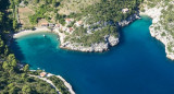
There are several bays, including its N side, where it is possible to anchor. On the other side there is an anchor in front Gradisce.
31 May 11
Jojo

Otoci Pakleni

15nm
272°
Plakeni islands, or Cursed Islands, are located at the W and S of Hvar town.

The islands are rocky, covered with bushes and trees. They are usually deserted, except in summer.
They offer many choices of moorings sheltered and there is a marina Palmizana.The islands'name ...
26 May 11
Jojo

Otok Scedro Hvar

4nm
207°
Otok Scedro lies 3 miles E of Hridi Lukavci.
It is 2,7 km off the S coast of island of Hvar.The inhabited island is elevated at each end and slopes towards the sea in the middle. Its coastline includes many coves where you can get wet. The two most popular are Uvala Uvala Lovisce ...
25 May 11
Jojo

Uvala Vela Luka Korcula

11nm
194°
Zaljev Vela Luka is a large bay on the E O. Korcula. Many coves occupy the bay. At the bottom of it is the port of Vela Luka, an active and well sheltered.
Easily identifiable by day or night, you can enter this great bay in all weather.
Dangers in the general approach are the ...
21 May 11
Jojo

Pakleni Kanal

15nm
275°
Pakleni Kanal lies between Pakleni Otoci and Otok Hvar.
It is a deep and wide channel, with access at both ends, which leads to Luka Hvar.
This channel is frequented by small vessels with local knowledge and affords good shelter from the bora, although heavy squalls may be encountered.
The ...
30 May 11
Jojo

Uvala Mala Stiniva Hvar

1.6nm
70°
Mala Stiniva Bay is famous for its picturesque cliffs which fall sheer into the sea is composed of two coves separated by a rock.
We anchored for a lunch stop in this beautiful setting.
2 Jun 11
Jojo