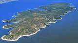
Zaljev Vela Luka is a large bay on the E O. Korcula. Many coves occupy the bay. At the bottom of it is the port of Vela Luka, an active and well sheltered. Easily identifiable by day or night, you can enter this great bay in all weather. Dangers in the general approach are the ...
Starogradski is a large deep bay, open to the NW, which houses the city and the port of Stari Grad on its SE end. There are several bays, including its N side, where it is possible to anchor. On the other side there is an anchor in front Gradisce.
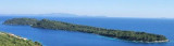
Zvirinovikis a small uninhabited island located S from Korcula island, in front of Karbuni hamlet.Its area is 0.405 square kilometers. It offers 4.21 km length of coast and rises to 56 m. The island can be circumvented by N or S. Coming from the S, attention to the island ...
Otok Scedro lies 3 miles E of Hridi Lukavci. It is 2,7 km off the S coast of island of Hvar.The inhabited island is elevated at each end and slopes towards the sea in the middle. Its coastline includes many coves where you can get wet. The two most popular are Uvala Uvala Lovisce ...
L'île Kopiste appartient au groupe d'îles du parc naturel de Lastovo. Elle est située à l'W de Lastovo après O. Przba et O. Mrcara dont elle est séparée par le canal de Zaplja. Elle est entourée de trois îlots: O. Bijelac, O. Pod Kopiste et O Crnac.
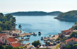
Grscica is a village located on the southern side of the island of Korcula, 14 km away from Vela Luka. Warning, approaching the port, submerged rock, covered by 1.2 m of water in the middle of the outer harbor, SW of the hold. We moored at the wharf near the dock. Open to the SW.


 A bay located on the NE coast of O. Zvirinovik, offers a sheltered anchorage by 7 to 10 m.
 Une baie, située sur la côte NE d'O. Zvirinovik, offre un mouillage abrité par 7 à 10 m.