These two islands, with the W Perast shores are an area with shallower N Otok Lady Skrpjela od. There is a 4 m deep between the islands. Can moor at the wharf O. Lady od Skrpjela to visit the church and the museum, but if a tour boat arrives, it will move and dock-side of the latter. Island Lady od Skrpjela is artificial. It was built by the inhabitants of Perast on a reef.
The island of Sveti Djordje was the site of the Benedictine abbey of the largest Bay of Kotor. The abbey was pillaged and destroyed two times by the Turks and endomagée by earthquakes. Sv Djordje today is ringed by'un high wall surrounding a church, a cemetery and cypresses.
2011/04/10
Update
Jojo
Otoci Gospa od Skrpjela - Sv Djordje
2011-04-10
Update
Jojo
Ces deux îles, à l'W de Perast, sont accores avec une zone moins profonde au N d'Otok Gospa od Skrpjela. Il y a 4 m de fond entre les îles.
On peut s'amarrer au quai d'O. Gospa od Skrpjela pour visiter l'église et le musée, mais si un bateau d'excursion arrive, il faudra se déplacer et s'amarrer à couple de ce dernier.
L'île de Gospa od Skrpjela est artificielle. Elle a été construite par les habitants de Perast sur un récif.
L'île de Sveti Djordje fut le site de l'abbaye bénédictine la plus importante des Bouches de Kotor. L'abbaye fut pillée et détruite 2 fois par les turcs et endommagée par les tremblements de terre. Aujourd'hui Sv Djordje est cernée d''un haut mur qui entoure une église, un cimetière et des cyprès.
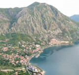
The middle bay of Boka Kotorska, is connected to Topaljski Zaliv by Kumborski Strait, a deep passage. This bay is steep and rocky on its S side, but the NE and NW shores, which are backed by mountains, are low and cultivated. Uvala Kukuljina and UvalaKrtole, separated from each ...
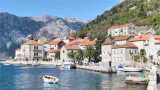
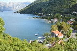
Perast is a pretty little fishing village. Perast is NE Prolaz Verige, the channel between Kotorska Zaljev and Tivaski Zaljev. The islands Lady od Skrpjela and Djordje are in W Perast and do not fire. The dock is Perast near the church and the great bell. Moored alongside ...
The town of Risan, located at N Kotorska Zaljev, is protected by high limestone cliffs of the mountain Orjen. It offers a small sheltered harbor. We moored alongside the wharf. For NE wind, the best location is on the outside of it. You can anchor in 6 to 12 m. The Bora blows ...
Donji Morinj is located at the W Kotorska Zaljev in Morinjski Zaliv. This quiet bay allows a stop for lunch and swimming, but at night, often, strong gusts katabatic flow down the mountains behind Risan. They then make the anchorage unsafe. There is no danger in the approach. A ...
Tivat is a luxury yacht marina and adjacent waterfront
development currently under construction. The construction site was a
naval shipyard named Arsenal, which fell into disuse after the wars and
the decline of the Yugoslav Navy. The attractive lot on which the
shipyard is situated ...
Tivat is located on the coast of E Tivatski Zaljev is an administrative center and a tourist town. Nearby there is an airport and an arsenal. The public dock is located SE of the arsenal. Can moor along the wharf next available space. The dock is dangerous winds W.


 quai à Gospa od Skrpjela
 These two islands, with the W Perast shores are an area with shallower N Otok Lady Skrpjela od. There is a 4 m deep between the islands.
 Ces deux îles, à l'W de Perast, sont accores avec une zone moins profonde au N d'Otok Gospa od Skrpjela. Il y a 4 m de fond entre les îles.