robinets près des parterres de fleurs sur le quai.
en ville
Description
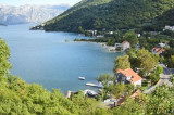
The town of Risan, located at N Kotorska Zaljev, is protected by high limestone cliffs of the mountain Orjen. It offers a small sheltered harbor. We moored alongside the wharf. For NE wind, the best location is on the outside of it. You can anchor in 6 to 12 m. The Bora blows hard in Risan, but does not lift the sea W winds make the outside of the dike uncomfortable. The port offers good protection.
2011/04/10
Update
Jojo
La ville de Risan, située au N de Kotorski Zaljev, est protégée par les hautes falaises de calcaire de la montagne Orjen. Elle offre un petit port abrité.
On s'amarre le long du quai. Par vent de NE, le meilleur emplacement est sur le côté extérieur de celui-ci. On peut mouiller par 6 à 12 m.
La Bora souffle fort à Risan, mais ne lève pas la mer. Les vents d'W rendent l'extérieur de la digue inconfortable. Le port offre une bonne protection.
The middle bay of Boka Kotorska, is connected to Topaljski Zaliv by Kumborski Strait, a deep passage. This bay is steep and rocky on its S side, but the NE and NW shores, which are backed by mountains, are low and cultivated. Uvala Kukuljina and UvalaKrtole, separated from each ...
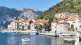
Perast is a pretty little fishing village. Perast is NE Prolaz Verige, the channel between Kotorska Zaljev and Tivaski Zaljev. The islands Lady od Skrpjela and Djordje are in W Perast and do not fire. The dock is Perast near the church and the great bell. Moored alongside ...
These two islands, with the W Perast shores are an area with shallower N Otok Lady Skrpjela od. There is a 4 m deep between the islands. Can moor at the wharf O. Lady od Skrpjela to visit the church and the museum, but if a tour boat arrives, it will move and dock-side of the latter. Island ...
Donji Morinj is located at the W Kotorska Zaljev in Morinjski Zaliv. This quiet bay allows a stop for lunch and swimming, but at night, often, strong gusts katabatic flow down the mountains behind Risan. They then make the anchorage unsafe. There is no danger in the approach. A ...
Tivat is a luxury yacht marina and adjacent waterfront
development currently under construction. The construction site was a
naval shipyard named Arsenal, which fell into disuse after the wars and
the decline of the Yugoslav Navy. The attractive lot on which the
shipyard is situated ...
Tivat is located on the coast of E Tivatski Zaljev is an administrative center and a tourist town. Nearby there is an airport and an arsenal. The public dock is located SE of the arsenal. Can moor along the wharf next available space. The dock is dangerous winds W.


 robinets près des parterres de fleurs sur le quai.
 en ville


 The town of Risan, located at N Kotorska Zaljev, is protected by high limestone cliffs of the mountain Orjen. It offers a small sheltered harbor.
 La ville de Risan, située au N de Kotorski Zaljev, est protégée par les hautes falaises de calcaire de la montagne Orjen. Elle offre un petit port abrité.