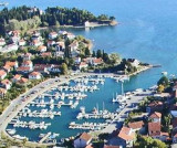
Tivat is located on the coast of E Tivatski Zaljev is an administrative center and a tourist town. Nearby there is an airport and an arsenal. The public dock is located SE of the arsenal. Can moor along the wharf next available space. The dock is dangerous winds W.
2011/04/9
Update
Jojo
Tivat est situé sur la côte E de Tivatski Zaljev, c'est un centre administratif et une ville touristique. A proximité il y a un aéroport et un arsenal.
Le quai public se trouve au SE de l'arsenal. On peut s'amarrer le long du quai suivant la place disponible. Le quai est dangereux par vents d'W.
The middle bay of Boka Kotorska, is connected to Topaljski Zaliv by Kumborski Strait, a deep passage. This bay is steep and rocky on its S side, but the NE and NW shores, which are backed by mountains, are low and cultivated. Uvala Kukuljina and UvalaKrtole, separated from each ...
Tivat is a luxury yacht marina and adjacent waterfront
development currently under construction. The construction site was a
naval shipyard named Arsenal, which fell into disuse after the wars and
the decline of the Yugoslav Navy. The attractive lot on which the
shipyard is situated ...
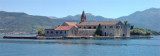
The Marina Kalimanj in Tivat is a well protected marina, a natural harbour, where the docking locations are safe. All around the Marina there are ancient Venetian palaces protected by UNESCO, old churches, restored stables. The name Tivat comes from the Celtic word "teuta", meaning town.
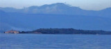
Ostrvo Stradioti, the largest of the islands lying in the SE part of the bay, is 37m high and is marked by several beacons at its W extremity. It is easily recognized against the lowlands in the background.
Plicina Jezicac, nearly awash, lies at the outer end of a spit which extends about 0.5 mile WNW from the N extremity of Ostrvo Stradioti. Vessels should not attempt to pass between this reef and the islands to the E.


 Tivat is located on the coast of E Tivatski Zaljev is an administrative center and a tourist town.
 Tivat est situé sur la côte E de Tivatski Zaljev, c'est un centre administratif et une ville touristique.