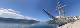

Boka Kotorska
23nm
310°
Prevlaka ...
12 Apr 11
Jojo
| Latitude | Longitude | |
| DMS | --- | --- |
| DM | --- | --- |
| DD | --- | --- |


 Montenegro, called "the pearl of the Mediterranean" is located in the Balkans. This is an area of relatively rectangular shape, bounded on the south by the Adriatic Sea to the west by Croatia and Bosnia-Herzegovina, Serbia by the North, North-East in Kosovo and finally in the South East by Albania.
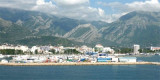
Although having a wide outlet to the sea (295 km of coastline), the country has no major port because of a very rugged coastline.
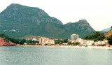
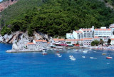
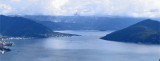
The Gulf of Kotor or Kotor Bay, is a huge spectacular bay, almost closed, consists of three basins lined with villages and dominated by high mountains, some of which reach 1000 m.
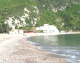
The bottom is mostly mud near the middle of the basins and sand, mud, and shells near the shores.
The tidal range in this region is low (about 30 cm). Tidal currents are weak and are not normally visible.
The circular flow is NW and varies from 0.5 to 2 knots in good weather. The strength and direction of this current are influenced by the strength and direction of wind. Winds from SW, the direction of current flows to the NE, which will tend to carry the boats to the coast.
A stream flowing off sometimes occurs at the entrance to Kotor Bay, the sea can be rough when there is a stream flowing offshore to where it meets the current circular on the NW.
In this region the winds tend to be deflected by the high mountains near the coast, especially in the S. They are usually SE or NW. Sea breezes, adopted by the mountains, reinforcing the prevailing winds. This may be a wind NW force 3 to force 5 in the afternoon. The wind normally falls during the evening, leaving a choppy sea. Although the winds are most common N in summer, there are periods of SE winds.
This region is subject to katabatic winds. They are stronger in winter, when mild temperatures at sea level coupled with very low temperatures in the mountains can create strong local winds (Bora). Katabatic winds also occur in summer, with the effects of "downs" running down the mountains.
Especially the Bora blows violently Bar. In the Bay of Kotor, the strongest winds occur in the Bay of Risan.
 Le Monténégro, appelé "la perle de la Méditerrané", est situé dans les Balkans. C'est un territoire de forme relativement rectangulaire, bordé au Sud par la mer Adriatique, à l'Ouest par la Croatie et la Bosnie-Herzégovine, au Nord par la Serbie, au Nord-Est par le Kosovo et enfin au Sud-Est par l'Albanie.
Bien que disposant d'un large débouché sur la mer (295 km de côte), le pays ne dispose pas de port important en raison d'un littoral très accidenté.
Le golfe de Kotor ou Bouches de Kotor, est une immense baie spectaculaire, pratiquement fermée, constituée de trois bassins bordés de hameaux et dominés par de hautes montagnes dont certaines atteignent 1000 m.
Les fonds sont généralement boueux au centre des bassins et près des rivages ils sont formés d'un mélange de sable, boue et coquillages.
Au S du Monténégro, Bar est le port principal du Monténégro.
Le marnage dans cette région est faible (environ 30 cm). Les courants de marée sont faibles et ne sont normalement pas perceptibles.
Le courant circulaire porte au NW et varie de 0,5 à 2 nœuds par beau temps. La force et la direction de ce courant sont influencés par la force et la direction du vent. Par vent de SW, la direction du courant passe au NE, ce qui aura tendance à porter les bateaux à la côte.
Un courant portant au large se rencontre parfois à l'entrée des Bouches de Kotor, la mer peut être agitée lorsqu'il existe un courant portant au large, à l'endroit où il rencontre le courant circulaire portant au NW.
Dans cette région les vents ont tendance à être défléchis par les hautes montagnes toutes proches de la côte, en particulier dans le S. Ils sont donc d'habitude NW ou SE. Les brises de mer, arrêtées par les montagnes, renforcent les vents dominants. Cela peut faire passer un vent de NW de force 3 à force 5 l'après-midi. Le vent tombe normalement durant la soirée, laissant une mer agitée. Bien que les vents du N soient plus courants en été, il y a des périodes de vents de SE.
Cette région est sujette aux vents catabatiques. Ils sont plus forts en hiver, où des températures douces au niveau de la mer couplées à de très basses températures dans les montagnes peuvent créer des forts vents locaux (Bora). Des vents catabatiques se rencontrent aussi en été, avec des effets de "rabattants" dévalant les montagnes.
La Bora souffle particulièrement violemment à Bar. Dans les Bouches de Kotor, les vents les plus forts se produisent dans la baie de Risan.
Ebook | Montenegro
|