

Tivaski Zaliv
2.2nm
150°
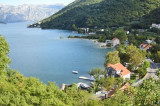
This bay is steep and rocky on its S side, but the NE and NW shores, which are backed by mountains, are low and cultivated.
Uvala Kukuljina and UvalaKrtole, separated from each ...
12 Apr 11
Jojo
| Latitude | Longitude | |
| DMS | --- | --- |
| DM | --- | --- |
| DD | --- | --- |


Ebook | Montenegro
|
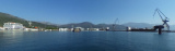
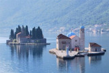
 The Bay of Kotor (Serbian:Boka kotorska; Croatian: Boka Kotorska; Italian: Bocche di Cattaro) in southwestern Montenegro, is a winding bay on the Adriatic Sea. With the exception of the area of coast between Rt Ostra and Rt Kobila the Bay of Kotor are part of Montenegro.
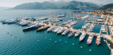
The largest of these bays is the Gulf of Tivat (Teodo), with a small harbor. On the part close to the sea is the Gulf of Herceg Novi (Castelnuovo), who guards the main entrance mouths. Other inner gulfs are those of Risan northwest of Kotor and the southeast.
In the entrance to the gulf the currents set to the NW along the E shore and SE along the W shore, frequently attaining a velocity of 2.5 knots in either direction. In the narrows of Kumbur the current usually sets to the W and is very strong, but in Verige the current is variable in direction and never exceeds a velocity of 0.5 knot under normal conditions.
Off the entrance to Boka Kotorska, the coastal current is deflected by an outflow caused by SE winds, which sets the water towards shore and causes eddies.
 Les bouches de Kotor (ou Boka Kotorska, en italien Bocca di Cattaro) sont une baie située sur la côte occidentale du Monténégro, dépendante de la mer Adriatique. A l'exception de la zone de côte située entre Rt Ostra et Rt Kobila, les bouches de Kotor font partie du Monténégro.
Le plus important de ces golfes est le golfe de Tivat (Teodo), abritant un petit port. Sur la partie proche de la mer se trouve le golfe de Herceg Novi (Castelnuovo), qui garde l'entrée principale des bouches. Les autres golfes intérieurs sont ceux de Risan au nord-ouest et celui de Kotor au sud-est.
Dans l'entrée du golfe, les courants vont au nord-ouest le long de la rive E et au SE le long de la rive ouest, en atteignant souvent une vitesse de 2,5 nœuds dans les deux sens.
Dans le passage du Kumbur le courant se trouve habituellement à l'Ouest et est très fort, mais dans Verige le courant est variable en direction, et ne dépasse jamais une vitesse de 0,5 nœud dans des conditions normales.
Hors de l'entrée de Kotor, le courant côtier est dévié par les vents SE, et forme des tourbillons vers le rivage.
Attention.-Dans la partie N de l'entrée du chenal menant à Kotor, les courantsNW et SE se rencontrent au changement de marée et avec un vent de S peuvent provoquer une mer forte et dangereuse dans ces parages.
La frontière entre le Monténégro et le littoral Croate se trouve dans le voisinage des Bouches de Kotor.