Molasses Reef (Key Largo)

Molasses Reef (Key Largo)

To precisely geolocate this site. Update if necessary.

Localisation

Molasses Reef (Key Largo)
LatitudeLongitude
DMS------
DM------
DD------

Characteristics

Mooring buoy
Mooring
Lighthouse
Diving
Wreck

Description


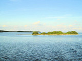
This is arguably the most beautiful collection of reefs in all of
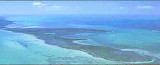
Florida! Rather than a single site, Molasses is an extensive reef complex with diving depths from about 10 feet to more than 70. At depths ranging from 10-40 feet, Molasses Reef features high profile spur and groove coral formations. At 40-60 feet down, seaward sand chutes separate a gently sloping hard flat bottom adorned by hard and soft corals, along with a variety of sponges. The "drop-off" begins in the
50-60 foot range, and extends downward at various angles to the 70-100 foot range. Excellent drift diving can be found here.
Certain areas have distinct features for which they have been named, such as Spanish Anchor Winch Hole, Fire Coral Caves, Hole in the Wall and many others. Snorkelers will enjoy the shallow spur and groove formations typified by Elkhorn and Boulder Corals punctuated by seafans.
Divers will find plenty to occupy them as well. Visibility is generally excellent on this reef as it is "rinsed" by the currents of the nearby gulfstream.
This is probably the most visited site in the Florida Keys and possibly the United States. Because of this, Marine officers generally patrol this area. These officers make sure that divers understand that even touching coral reef can kill these beautiful organisms. This site houses massive brain coral, star coral, and other large barrier corals.
Caves and ledges provide homes for lobsters, crabs, moray eels, parrot fish, angelfish, filefish, turtles, rays, and sometimes nurse sharks.
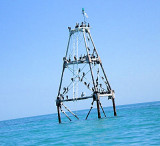
Divers will be able to come fairly close to these creatures. Sandy patches divide areas of coral and create an amazing sight. An old ship winch and an eight-foot anchor help to create the unique and interesting nature of this dive. Boaters must tie off to one of the 40 mooring buoys surrounding the large tower marking the reef.
This area was harmed when the freighter, Wellwood, ran aground here in
1984. Damaged areas are marked and should be avoided. Part of the remaining rubble from Wellwood is contained in the .3 square nautical mile Sanctuary Preservation Area (SPA) which reaches down to 60-feet.
This is a dive not to miss for anyone traveling to the area. Those looking to snorkel should stay to the northern, shallower end of the reef while divers will want to explore the southern end. This is also an easily accessible and highly used night-dive site.


Local legend suggests that Molasses is named for a barge that grounded here many years ago carrying a cargo of molasses barrels, but much of the strewn wreckage is probably from a wooden hulled Austrian ship named
Slobodna, run aground here in 1887.

2010/04/1
Update
bjvlb
Molasses Reef (Key Largo)
2010-04-01
Update
Joëlle
Molasses Reef (Key Largo)
2010-04-01
Update
Joëlle
Ebook

Gulf of Mexico

  • 227 sites
  • 182 photos
  • publication date: 9 Jul 2023
  • .pdf file size: 78 Mb
C'est sans doute la plus belle collection de récifs dans toute la Floride! Plutôt que d'un seul site, Molasses reef est un vaste complexe de récifs avec des profondeurs de plongée à partir d'environ 3 m à plus de 21 m. À des profondeurs allant 3/12 m, Molasses Reef éperon caractéristique, élevé avec formations de corail. À 12/18 m plus bas, le sable au larges chutes sépare un fond plat, rigide en pente douce orné de coraux durs et mous, avec une variété d'éponges. Le «Drop-off" commence dans la fourchette 15/18 m, et s'étend vers le bas à des angles variés au pied de la plage 21/30 m. On peut trouver ici une excellente plongée en dérive.
Certaines zones ont des caractéristiques distinctes pour lesquelles elles ont été nommées, comme l'espagnol Anchor Winch Hole, Corail de feu Caves, Hole in the Wall et beaucoup d'autres. Les plongeurs apprécieront l'éperon peu profond et les formations caractérisées par Elkhorn et Corals Boulder ponctuées par seafans. Ce coin est très fréquenté par les plongeurs. La visibilité est généralement excellente sur ce récif comme il est "rincé" par les courants de la Gulfstream à proximité.
C'est probablement le site le plus visité dans les Keys de Floride et éventuellement les
États-Unis. Pour cette raison, les agents maritimes patrouillent en général ce domaine. Les plongeurs doivent comprendre que même toucher des récifs coralliens peut tuer ces beaux organismes. Ce site héberge le corail massif des cerveaux, le corail étoile, et d'autres coraux barrière importants. Grottes et corniches fournissent des logements aux homards, crabes, murènes, poissons perroquets, poissons-anges, filefish, tortues, raies, et parfois des requins nourrice. Les plongeurs seront en mesure de venir assez proches de ces créatures. Les Patches Sandy divisent des zones de corail et créent un spectacle étonnant. Le vieux treuil d'un navire  et une ancre de 2,4 m contribuent à créer la nature unique et intéressant de cette plongée. Les plaisanciers doivent attacher leur bateau à l'une des 40 bouées d'amarrage autour de la grande tour marquant le récif.
Cette zone a été blessée lorsque le cargo, Wellwood, a échoué ici en 1984. Les zones endommagées sont marquées et doivent être évitées. Une partie des gravats restants de Wellwood est contenue dans la zone des 3 miles nautiques carrés, zone de préservation du Djoudj (SPA), qui descend à 18 m. C'est une plongée à ne pas manquer pour tous ceux qui voyagent dans la région. Ceux qui cherchent à faire de la plongée libre doivent rester dans la partie N, fin peu profonde du récif, tandis que les plongeurs pourront explorer l'extrémité sud. Il s'agit également d'un dispositif facilement accessible et très utilisé de nuit par les plongeurs.
La légende locale suggère que Molasses Reef est nommé ainsi car il y a de nombreuses années un navire à coque en bois autrichien nommé Slobodnatrans transportait probablement une cargaison de barils de mélasse, il s'est échoué ici en 1887 et  une grande partie de l'épave fut éparpillée.
2012/04/16
Update
JB
Share your comments or photos on "Molasses Reef (Key Largo)"

Sites around Molasses Reef (Key Largo)

Flying distances - Direct line

John Pennekamp Coral Reef State Park (Key Largo)

7.6nm
13°
The first underwater park in the U.S., John Pennekamp Coral Reef State
Park encompasses approximately 70 nautical square miles.
It is the coral reefs and their associated marine life that bring most visitors to the park.
Many enjoy the view of the reef from a glass-bottom ...
31 Mar 10
Joëlle

Long Key (ou Rattlesnake key) (Florida Keys)

24nm
244°
Long Key was called Cayo Vivora (Rattlesnake Key) by early Spanish explorers, a reference to the shape of the island, which resembles a snake with its jaws open, rather than to its denizens.
In the early 20th century, Long
Key was the site of a luxurious fishing resort that ...
5 Apr 10
Joëlle

Elliot Key (Florida)

27nm
20°
Elliott Key is the northernmost of the true Florida
Keys (those 'keys' which are ancient coral reefs lifted above the present sea level), and the largest key north of Key
Largo. It is located entirely within Biscayne National Park.
It is bordered by the Atlantic Ocean to ...
18 Apr 10
Joëlle

Mosquito Bank (Key Largo)

3.4nm
In the Key Largo Area are Mosquito Banks, at a short distance from the Pennekamp Coral Reef State Park. Mosquito Bank overlies a concave low-elevation indentation or reentrant in the bedrock depression beneath Hawk Channel. Sediments in Mosquito Bank are mostly muddy sands with ...
31 Mar 10
Joëlle

Rodiguez Key (Key Largo)

4.4nm
299°
Rodriguez Key is a nearshore mangrove island surrounded by a shallow mud bank. A branching-coral and coralline-algae zone protects the muddy surface and mangroves of the island.Northern anchorage is possible only when the weather is fair.
31 Mar 10
Joëlle

White Bank Dry Rocks (Key largo)

7.6nm
36°
Key Largo
Dry Rocks lies within the boundaries of the previous Key
Largo National Marine Sanctuary.Key Largo Dry Rocks is located seaward of White Banks and extends to an approximate depth of 30 feet. Dry Rocks SPA covers an area of approximately 0.05nm2, or about 16ha, and ...
1 Apr 10
Joëlle