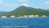
Marine de Meria, a small cove, is entered 1.5 miles SSE of Macinaggio and can be recognized by an old mill which stands on a rocky promontory on the N side.
A small town is situated near the shore at the head of the cove. Sommet Castello, 475m high, stands 1.5 miles WSW of the cove and can be seen over the intervening hills.
Anchorage is possible if good weather or W wind.
2012/05/1
Update
Jojo
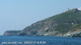
Tour remarquable.
2005-07-19
Bearing:300°
2005:07:19 20:17:49
2012-05-01
Update
Jojo
Marine de Meria est une petite anse située à 1,5 MN au SSE de Macinaggio et est reconnaissable grâce à son vieux moulin qui s'élève sur un promontoire rocheux sur le côté N de l'anse.
Une petite ville s'étend près de la rive au fond de l'anse. Le mont Castello (475 m de haut) s'élève à 1,5 MN à l'WSW de l'anse
Mouillage possible par beau temps ou vent d'ouest.
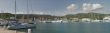
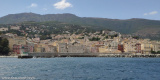
Cette commune de 86 habitants vous accueille avec une remarquable petite marine surplombée d'une tour génoise.
2012/05/1
Update
Jojo
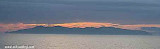
Ile d'Elbe vu depuis la Marine de Meria.
2005-07-19
Bearing:60°
Capo Sagro is located at 11 NM. S Finocchiarola islands. He has a signal station and a semaphore rises N of it. Mount Merizatodio, 778 m high, is 1.5 MN to W Cape and dominates the immediate area.
The village of Erbalunga, situated 1.5 miles SSW of Capo Sagro, stands on the S ...
Capraia is one of the seven islands of the Tuscan Archipelago, on the road between Cape Corsica and Elba. It is an island of 335 inhabitants (the Capraiesi) of the Province of Livorno. It lies 64 km from Livorno, 37 km from Gorgona and 31 km from Corsica. Its area is 19 km2. It has ...
Located between Marines de Sisco and Erbalunga, this point is well known to divers. Cape Sagro is an anchorage where the ancient Roman fleet landed the goods for this part of Cap Corse.
This site is of outstanding beauty and it is not unusual to see diving teams of experienced ...
Macinaggio, a village, is situated in a bay which is entered S of Pointe de la Coscia. It is fronted by a small harbor which is protected by two jetties and has extensive facilities for small craft and yachts. The harbour is not sheltered from wind. T. 04 95 35 42 57 F. 04 95 35 ...
Pointe de la Coscia, located 1 mile S of Sommet Tamarone, is the S entrance point of Baie de Tamarone. This bay is 0.7 mile wide and affords shelter from W winds. Surrounded by a beautiful sandy beach is a pleasant good weather anchorage.
The village of Luri is located in the heart of Cape Corse. Particularly
well protected harbor with a jetty semicircular with a depth of 3
meters to 2 meters and the entrance to the pier which is riprapped at
the base. Sheltered from northerly winds, a little ...


 Marine de Meria, a small cove, is entered 1.5 miles SSE of Macinaggio and can be recognized by an old mill which stands on a rocky promontory on the N side.
 Tour remarquable.
2005-07-19
Bearing:300°
Tour remarquable.
2005-07-19
Bearing:300° Marine de Meria est une petite anse située à 1,5 MN au SSE de Macinaggio et est reconnaissable grâce à son vieux moulin qui s'élève sur un promontoire rocheux sur le côté N de l'anse.
 Ile d'Elbe vu depuis la Marine de Meria.
2005-07-19
Bearing:60°
Ile d'Elbe vu depuis la Marine de Meria.
2005-07-19
Bearing:60°