
Isola Capraia
23nm
39°
26 Feb 14
marchew
| Latitude | Longitude | |
| DMS | --- | --- |
| DM | --- | --- |
| DD | --- | --- |


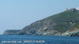
 Capo Sagro is located at 11 NM. S Finocchiarola islands. He has a signal station and a semaphore rises N of it.
Mount Merizatodio, 778 m high, is 1.5 MN to W Cape and dominates the immediate area.
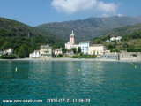
The village of Erbalunga, situated 1.5 miles SSW of Capo Sagro, stands on the S side of a rocky point.
Tour de Miomo is situated 2 miles S of Erbalunga and stands near a group of houses on a rocky point which overlooks a small beach.
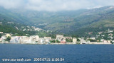
Punta Toga is located 2 miles S of Tour de Miomo and has a large steel works situated close SSW of it.
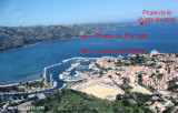
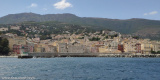
Bastia, S Punta Toga, is the principal commercial port of Corse.

 Capo Sagro est situé à 11 MN au S des îles Finocchiarola. Il porte un phare et un sémaphore s'élève au N de celui-ci.
Le mont Merizatodio, haut de 778 m, s'élève à 1,5 MN à l'W du cap et domine la zone immédiate.
Le village d'Erbalunga, situé à 1,5 MN au SSW de Cap Sagro, s'élève au S du point rocheux.
La tour de Miomo se trouve à 2 MN d'Erbalunga et s'élève près d'un groupe de maisons sur un point rocheux qui domine une petite plage.
La pointe Toga, à 2 MN au S de la tour Miomo, a une grande aciérie à son extrémité SSW.
Bastia, au S de la pointe Toga, est le principal port commercial de la Corse.


Ebook | Corse - Corsica
|