Marine de Luri - Santa Severa

Marine de Luri - Santa Severa

To precisely geolocate this site. Update if necessary.

Localisation

Marine de Luri - Santa Severa
LatitudeLongitude
DMS------
DM------
DD------

Characteristics

Port
VHF canal 9
Water
Phone
Electricity
Fuel
Slip
Shower
Restaurant

Description

Marine de Luri - Santa Severa
2007-07-11
Update
Mobile
Marine de Luri - Santa Severa
2008-10-17
Update
The village of Luri is located in the heart of Cape Corse.
Particularly well protected harbor with a jetty semicircular with a depth of 3 meters to 2 meters and the entrance to the pier which is riprapped at the base.
Sheltered from northerly winds, a little east, the SE enter in the port.

The town of Piazza Luri is 5 km inland.

Be wary of high rocky bottom N-E port.

     tel. 04 95 31 00 25
     TE <1.60 m
     155 bl. including 25 visit. (<12 m)
2012/05/3
Update
Jojo
Marine de Luri - Santa Severa
2005:07:20 09:59:26
2012-05-03
Update
Jojo
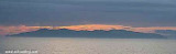
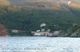
Le village de Luri est situé au coeur du Cap-Corse.
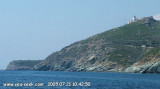
Petit port particulièrement bien protégé, avec une jetée semi-circulaire dont la profondeur est de 3 mètres à l'entrée et 2 mètres à la jetée qui est enrochée à la base.
Abrité des vents du Nord, un peu de l'Est, le S.E y rentre en plein.
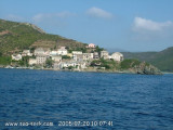
La ville Piazza de Luri est à 5 km dans les terres.
Se méfier du haut fond rocheux au N-E du port.
  • tél. 04 95 31 00 25
  • TE <1,60 m
  • 155 pl. dont 25 visit. (<12 m)

Histoire


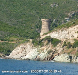
De 1030 à 1249 Luri fut le fief des Da Campo di Luri. Acquis en 1249 par le génois Ansaldo da Mare. Il s'intégra au fief Da Mare de San Columbano di Rogliano jusqu'à la conquête génoise de 1592. Une "consulte" eut lieu à Luri en 1762, où les responsables du Cap Corse décidèrent seulement alors de se rallier à Pascal Paoli. L'accès difficile de la vallée mit relativement les habitants à l'abri des incursions barbaresques au cours des siècles. Sénèque, selon une légende tenace, aurait été exilé à la tour qui porte son nom.
Luri a connu depuis le début 19ème une diminution de son activité agricole et de sa démographie, moins sensible toutefois que dans la plupart des autres communes du Cap Corse. La visite des hameaux et sites* composant la commune se fait en partant de la corniche littorale vers I'intérieur. Piazza : centre communal dans un environnement verdoyant*. A la fin 18ème, Piazza disputa à Rogliano le titre de capitale du Cap Corse, mais c'est cette dernière commune qui fut choisie.
2012/05/3
Update
Jojo
Ebook

Corse - Corsica

  • 247 sites
  • 631 photos
  • publication date: 6 Jul 2023
  • .pdf file size: 162 Mb
Share your comments or photos on "Marine de Luri - Santa Severa"

Sites around Marine de Luri - Santa Severa

Flying distances - Direct line

Cap Sagro - Bastia

8.5nm
178°
Capo Sagro is located at 11 NM. S Finocchiarola islands. He has a signal station and a semaphore rises N of it.
Mount Merizatodio, 778 m high, is 1.5 MN to W Cape and dominates the immediate area. The village of Erbalunga, situated 1.5 miles SSW of Capo Sagro, stands on the S ...
6 May 12
Jojo

Isola Capraia

17nm
58°
Capraia is one of the seven islands of the Tuscan Archipelago, on the road between Cape Corsica and Elba. It is an island of 335 inhabitants (the Capraiesi) of the Province of Livorno. It lies 64 km from Livorno, 37 km from Gorgona and 31 km from Corsica. Its area is 19 km2. It has ...
26 Feb 14
marchew

Cap Sagro

5.6nm
173°
Located between Marines de Sisco and Erbalunga, this point is well known to divers.
Cape Sagro is an anchorage where the ancient Roman fleet landed the goods for this part of Cap Corse.

This site is of outstanding beauty and it is not unusual to see diving teams of experienced ...
1 May 12
Jojo

Marine de Porticciolo

0.7nm
184°
Porticciolo or Porticiolo, is a marine of Cagnano Valley, located N of Bastia.

The houses, very old, were grouped  for a security issue, once. The roofs of local stone to retain its authentic small port.

If this small town had a relatively high until 1875 even with ...
3 May 12
Jojo

Tour de Losse

1.5nm
172°
The towers, square or circular, have always three floors: a level for water supplies, food and ammunition, another for life and the last for the day.
Their garrison, 2 to 4 men, assured the watch with the lights and regulatory signals in case of  risk, informed sailors, shepherds ...
3 May 12
Jojo

Marine de Meria

2.6nm
350°
Marine de Meria, a small cove, is entered 1.5 miles SSE of Macinaggio and can be recognized by an old mill which stands on a rocky promontory on the N side.
A small town is situated near the shore at the head of the cove. Sommet Castello, 475m high, stands 1.5 miles WSW of the ...
1 May 12
Jojo