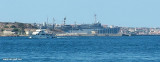
The approach of the marina is on the E side of the Maddalena, in front of Caprera Island near the bridge that connects the two islands. This marina has moderate capacity and offers pontoons and buoys for boating.
L'approche de la marina se fait sur la côte E de la Maddalena, en face de l'île Caprera près du pont qui relie les deux îles.
Cette marina, de capacité modérée dispose de pontons flottants et de bouées pour la plaisance.
L'approdo Marina del Ponte si trova sulla costa est dell'isola di La
Maddalena, di fronte all'Isola di Caprera nei pressi del ponte che
collega le due isole. L'ormeggio delle imbarcazioni si effettua su
pontili galleggianti e alla boa.
It is the largest island of the archipelago composed of sixty islets and 7 major islands, in the NE end tip of Sardinia. It is mountainous and arid. This is the only inhabited island thoroughly. It is connected by a bridge to Caprera island where are the house and the tomb of Garibaldi. ...
Gulf of Arzachena (Arsachena), located between Punta Saline and Tre Monti Cape, is a high inlet whose banks are lined with shoals. S tip, Arzachena, W of the entrance, a beacon consists of an iron post with a sheer spherical white marks a rock particularly ...
La tourelle Pecorella marque l'entrée de ce golfe qui s'enfonce à plus de 4 M dans les terres. Celle de Chiapino qui était plus au S est démolie. Il faut donc remonter suffisamment vers le N pour ne pas risquer d'en toucher les restes. En piquant vers l'W, la balise noire délimite ...
SW of Corsica offers some of the most beautiful anchorages. As you get closer to Bonifacio be carreful with the weather forecast as the NW wind can be very strong.
The range of the tide in this area is negligible. There are no regular currents along the coasts of Corse, ...
A little less than 1 NM to the E of Ventotene island, there is the island of Santo Stefano, the smallest of the archipelago.
This island is occupied by the army. Currently there is a NATO base on the island of Santo Stefano. The NATO base housed an Italian Marine barracks ...


 canal 9


 The approach of the marina is on the E side of the Maddalena, in front of Caprera Island near the bridge that connects the two islands.
 L'approche de la marina se fait sur la côte E de la Maddalena, en face de l'île Caprera près du pont qui relie les deux îles.
 L'approdo Marina del Ponte si trova sulla costa est dell'isola di La
Maddalena, di fronte all'Isola di Caprera nei pressi del ponte che
collega le due isole.
L'approdo Marina del Ponte si trova sulla costa est dell'isola di La
Maddalena, di fronte all'Isola di Caprera nei pressi del ponte che
collega le due isole.") Passage entre la Maddalena et Caprera vue du nord.
Passage entre la Maddalena et Caprera vue du nord.")
")
")