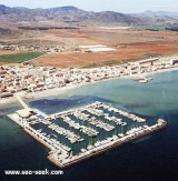
Mar Menor is a salty lagoon, in the south-east of the autonomous community of Murcia, in Spain, separated from the Mediterranean sea by La Manga, a sandbar 22km in length and with a width ranging from 100 to 1200 m.
With a surface area of nearly 170km², a coastal length of 70km, and warm and clear water no more than 7 m in depth, it is "the largest swimming pool in the world".Several small yacht harbors are situated within this lagoon. The northern end is a natural park.The average draft is 5m.
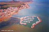
The entrance is through the port of Tomas Maestre (marina). It was not until the opening of a bridge (pairs every two hours during one quarter of an hour) into the Mar Menor.
2012/05/16
Update
Jojo
La Mar Menor est une lagune, au sud-est de la région de Murcie, séparée de la mer Méditerranée par un cordon littoral appelé La Manga de 21 km de long et d'une largeur variable de 100 à 1200 mètres.Avec près de 170 km² de surface et 70 km de côtes, une eau salée assez sombre
mais chaude qui ne dépasse pas 7 m de profondeur, c'est « la plus grande
piscine du monde ». Sa partie nord est un parc naturel.Le tirant d’eau moyen est de 5m.
L’entrée se fait par le port de Tomas Maestre
(marina). Il faut attendre l’ouverture d’un pont (toutes les deux
heures paires pendant 1/4 d’heure) pour pénétrer dans la Mar Menor.
Hormigas islands located in the region of Murcia, 2MN and a half from the coast. Las Hormigas, formed by a chain of islets and rocky shoals, extends up to 3 miles NE of Cabo de Palos.
Islas Hormiga, the largest islet of this chain, lies 2.3 miles NE of the ...
Port formed by two wharfs in the shape of "L", one from the beach and the second from the previous. The entrance is about 20 m wide.T. 968.574.316F. 968.575.129282 b. (<15 m)
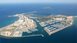
This yacht club forms an island 100 meters from the beach, S Los Urrutias town and SW Mar Menor. A bridge connects it to the mainland. It has an hexagonal shape that provides a protected lagoon inside.
T. 968 134438 F. 968 134438 Mail:
informacion@clubregatasmarmenor.com 280 ...
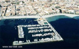
S of the Manga, strip of sand 22km long and 100-800 m wide, is the Port Tomas Maestre, along the Mar Menor.
Access to the marina from the Mediterranean, is through a channel of 1, 5 m with swing bridge (pairs every two hours during one quarter of an hour), which joins the sea ...
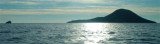
Isla Grosa, 95m high, lies 1.5 miles offshore, 3.7 miles NNE of Punta de Calnegre. This island is high, steep-sided, and flat-topped. A light is shown from a structure standing on the summit.
Anchorage, sheltered from E winds, can be obtained by vessels with local knowledge, ...
Located in Los Nietos hamlet, at 0.9 NM from Islas Menores marina, Los Nietos harbor is protected by a seawall and connected to the mainland by a bridge. Mail: administracion@cnlosnietos.comT. 968 133 300Fax. 968 133 640Mail: administracion@cnlosnietos.com450 ...


 Mar Menor is a salty lagoon, in the south-east of the autonomous community of Murcia, in Spain, separated from the Mediterranean sea by La Manga, a sandbar 22km in length and with a width ranging from 100 to 1200 m.
 La Mar Menor est une lagune, au sud-est de la région de Murcie, séparée de la mer Méditerranée par un cordon littoral appelé La Manga de 21 km de long et d'une largeur variable de 100 à 1200 mètres.Avec près de 170 km² de surface et 70 km de côtes, une eau salée assez sombre
mais chaude qui ne dépasse pas 7 m de profondeur, c'est « la plus grande
piscine du monde ».
La Mar Menor est une lagune, au sud-est de la région de Murcie, séparée de la mer Méditerranée par un cordon littoral appelé La Manga de 21 km de long et d'une largeur variable de 100 à 1200 mètres.Avec près de 170 km² de surface et 70 km de côtes, une eau salée assez sombre
mais chaude qui ne dépasse pas 7 m de profondeur, c'est « la plus grande
piscine du monde ».