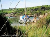
Sumartin was founded in the seventeenth century by refugees driven out of the continent by the Turks. The port is used by the car ferry and fishing boats.
2011/07/5
Update
Jojo
Sumartin fut fondé au milieu du XVIIème siècle par des réfugiés du continent chassés par les Turcs. Le port est utilisé par le car-ferry et par des bateaux de pêche.
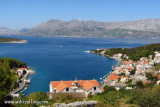
Starogradski is a large deep bay, open to the NW, which houses the city and the port of Stari Grad on its SE end. There are several bays, including its N side, where it is possible to anchor. On the other side there is an anchor in front Gradisce.
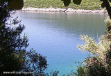
This creek is considered the most beautiful in Croatia by the navigational guide to Imray and yes she is beautiful with beautiful turquoise color and fragrant pines. The only problem is congestion. If the bottom of the cove is fully occupied, it must anchor in the front by 12 meters ...
Ciovo is an island in the center of the Dalmatian archipelago. This is an area of 28.8 acres (15.3 km length, width of 3.5 km). It culminates at 218 m (Mount Rudin). O. Ciovo forms the SW side of the entrance and inner part of Kastelanski Zaliv. At East side, Ciovo is 2km from ...
Povlja is a village NE of Brac. The best shelter is located behind the wharf where to moor at right angles if possible. You can anchor in the NW of the pier by 8 m of water.
Plakeni islands, or Cursed Islands, are located at the W and S of Hvar town.
The islands are rocky, covered with bushes and trees. They are usually deserted, except in summer. They offer many choices of moorings sheltered and there is a marina Palmizana.The islands'name ...


 au poste d'amarrage du ferry

")
")
 Sumartin was founded in the seventeenth century by refugees driven out of the continent by the Turks. The port is used by the car ferry and fishing boats.
 Sumartin fut fondé au milieu du XVIIème siècle par des réfugiés du continent chassés par les Turcs. Le port est utilisé par le car-ferry et par des bateaux de pêche.