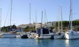
The bay is surrounded by houses, restaurants and a popular campground. There is a sheltered anchorage, a small port and marina to the east of the bay in Podstrana. We can moored at the breakwater by 1-4 m, or anchor by 2-4 m, or go to the marina in Podstrana. Good protection except from Bora and winds from the SE.
2011/04/3
Update
Jojo
La baie est entourée de maisons, de restaurants, et d'un camping très fréquenté. On y trouve un mouillage abrité, un petit port et une marina à l'E de la baie à Podstrana.
On peut s'amarrer au brise-lames par 1 à 4 m, mouiller par 2 à 4 m, ou aller à la marina à Podstrana.
Bonne protection sauf de la Bora et des vents du SE.
Ciovo is an island in the center of the Dalmatian archipelago. This is an area of 28.8 acres (15.3 km length, width of 3.5 km). It culminates at 218 m (Mount Rudin). O. Ciovo forms the SW side of the entrance and inner part of Kastelanski Zaliv. At East side, Ciovo is 2km from ...
Starogradski is a large deep bay, open to the NW, which houses the city and the port of Stari Grad on its SE end. There are several bays, including its N side, where it is possible to anchor. On the other side there is an anchor in front Gradisce.
Plakeni islands, or Cursed Islands, are located at the W and S of Hvar town.
The islands are rocky, covered with bushes and trees. They are usually deserted, except in summer. They offer many choices of moorings sheltered and there is a marina Palmizana.The islands'name ...
Pakleni Kanal lies between Pakleni Otoci and Otok Hvar. It is a deep and wide channel, with access at both ends, which leads to Luka Hvar. This channel is frequented by small vessels with local knowledge and affords good shelter from the bora, although heavy squalls may be encountered. The ...
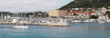
The main feature of this port city is quite disturbing: the old town lies within the remains of a palace that belonged to one of the last Roman emperors. The south port (Gradska Luka) is open to the south and a few times a year (late fall, winter, early spring) strong southwesterly ...


 Bonne tenue
 marina ou robinet à Stobrec
 sur la plage


 The bay is surrounded by houses, restaurants and a popular campground.
 La baie est entourée de maisons, de restaurants, et d'un camping très fréquenté.