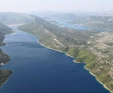
Sobra Luka is the port of Babino Polje, the main village of Mljet. There is a large open bay to the NE. Much of the bay is shallow or rocky, you can not anchor in the bay. We can tie the little dock that is located in the SW corner of the bay or wharf near the ferry pier. O. Badanj (on the E side of the entrance) was related to O. Mljet is the location of the Ferry and the fuel berth. The bay is exposed to Bora and Sirocco, the best protection of these two winds is E, near the ferry pier.
Écouter
Lire phonétiquement
2011/05/8
Update
Jojo
Quai du Ferry
2011-05-08
Update
Jojo
Luka Sobra est le port de Babino Polje, le village principal de Mljet. Il se trouve dans une grande baie ouverte au NE.
Une grande partie de la baie est profonde ou rocheuse, on ne peut donc pas mouiller dans cette baie. On peut s'amarrer au petit quai qui se trouve dans l'angle SW de la baie ou au quai près de la jetée du Ferry.
O. Badanj (sur le côté E de l'entrée) a été reliée à O. Mljet et est l'emplacement du Ferry et du poste de carburant.
La baie étant exposée à la Bora et au Sirocco, la meilleure protection de ces deux vents se trouve à l'E, près de la jetée du Ferry.
It is the largest and most populated island of the group Elafiten. It rises to 234 m at its N and a prominent hill rises 224 m NW of the SE end. Ruda is a small island that is 0.5 M SE of the NE extremity of the island and Misnjaka, 13 m high, lies close off the NW extremity. ...
Stonski Kanal, a deep inlet, indents the SE end of Poluotok Peljesac at the NW end of Kolocepski Kanal. Its shore rises rapidly on each side and provides protection from NE and SW winds. The village of Brocej is situated on the S shore 3.8 miles within the entrance. It is fronted ...
The narrow sea from Zaliv Klek Neum is 4 NM long and lies at the NE channel Malog Stone. It is surrounded by mountains and is inserted between Rt Rep Kleka and Rt Meded. Depths exceeding 20 meters in most cases. There are several anchorages. The SE part and W peninsula ...
Otoc Jakljan, fronted by islets (Kosmec and Crvina) on its N side, lies close NW of the SW extremity of Otoc Sipan. A white stony peak, 225m high, stands near the center of this island and is conspicuous from seaward. Jakljan island is separated of Sipan by a narrow passage, ...
This pretty bay is protected by islands at its entrance (W Galicnjak, Borovac Planjak) and some islets. The safest approach is to move to the W Borovac and to drive S to anchorage. You can anchor with 6 to 14 m in the middle of the bay. Bay unprotected Bora and the NW.


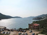
 quai Ferry
 quai Ferry
 quai Ferry
 Babino Polje
 Babino Polje
 Sobra Luka is the port of Babino Polje, the main village of Mljet. There is a large open bay to the NE.
 Luka Sobra est le port de Babino Polje, le village principal de Mljet. Il se trouve dans une grande baie ouverte au NE.