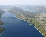
This pretty bay is protected by islands at its entrance (W Galicnjak, Borovac Planjak) and some islets. The safest approach is to move to the W Borovac and to drive S to anchorage. You can anchor with 6 to 14 m in the middle of the bay. Bay unprotected Bora and the NW.
2011/05/9
Update
Jojo
Cette jolie baie est protégée par des îles à son entrée (O. Galicnjak, Borovac, Planjak) et quelques îlots.
L'approche la plus sûre est de passer à l'W de Borovac et de faire route au S vers le mouillage.
On peut mouiller par 6 à 14 m au milieu de la baie.
It is the largest and most populated island of the group Elafiten. It rises to 234 m at its N and a prominent hill rises 224 m NW of the SE end. Ruda is a small island that is 0.5 M SE of the NE extremity of the island and Misnjaka, 13 m high, lies close off the NW extremity. ...
Stonski Kanal, a deep inlet, indents the SE end of Poluotok Peljesac at the NW end of Kolocepski Kanal. Its shore rises rapidly on each side and provides protection from NE and SW winds. The village of Brocej is situated on the S shore 3.8 miles within the entrance. It is fronted ...
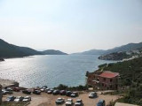
The narrow sea from Zaliv Klek Neum is 4 NM long and lies at the NE channel Malog Stone. It is surrounded by mountains and is inserted between Rt Rep Kleka and Rt Meded. Depths exceeding 20 meters in most cases. There are several anchorages. The SE part and W peninsula ...
Otoc Jakljan, fronted by islets (Kosmec and Crvina) on its N side, lies close NW of the SW extremity of Otoc Sipan. A white stony peak, 225m high, stands near the center of this island and is conspicuous from seaward. Jakljan island is separated of Sipan by a narrow passage, ...
The city is virtually invisible Okuklje wide, it is 10 km E of Sobra. The shape of the bay is almost closed Okuklje and is a good anchorage, protected from all sectors. At the entrance of Luka Okuklje, fire on the tip to the W of Rt Stoba appears. Stay in the middle of the entrance, ...


 This pretty bay is protected by islands at its entrance (W Galicnjak, Borovac Planjak) and some islets.
 Cette jolie baie est protégée par des îles à son entrée (O. Galicnjak, Borovac, Planjak) et quelques îlots.