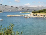
Orebic is situated on the southwestern part of the Peljesac peninsula at the bottom of the hill of St. Ilija. The port is located to the W of the city. Beware Ferries moored at the end of the main breakwater. The port must not be approached by strong winds from S or W. Once inside the marina basin can secure at Pier S or one of the pontoons. You can anchor in the harbor by 4 W m 240 b. including 30 visit.
2011/04/26
Update
Jojo
Orebic est situé sur la partie sud-ouest de la péninsule de Peljesac au pied de la colline de St Ilija.
Le port se trouve à l'W de la ville. Attention aux Ferries qui s'amarrent au bout du brise-lames principal. Le port ne doit pas être approché par fort vent de S ou d'W.
Une fois entré dans le bassin de plaisance on peut aller s'amarrer au môle S ou à l'un des pontons. On peut mouiller à l'W du port par 4 m.
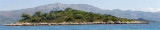
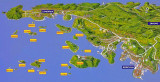
Skoji is a group of islands in Korcula Archipelago, located in Peljesac Channel in Croatia. There are all together 19 small islands that form this archipelago. Their names are : Badija, Kamenjak, Gojak, Planjak, Vrnik, Majsan, Majsanic, Gubavac, Knezic, Bisace, Sutvara, Stupe, Baretica, ...
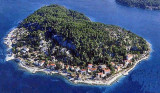
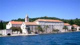
Badija is one of the largest island in the Korcula archipelago. It is situated on the east side of Korcula Old Town
, about twenty minutes boat ride from Korcula's harbour. It cover the
area one square km and is covered by dense maquis pine and cypress
trees.
Badija was ...
The small inhabited island of Korcula Vrnik is separated by a channel about 0.1 nm wide by 5 m deep. A hamlet northwest of the island has a small jetty where you can dock by 8 m. Good shelter except the SE. No service. Approaching from the NW Jezevica kanal, attention ...
The mooring and dock are Badija S of the island. We can not approach the E by the passage between the islands and Badija Planjak. This shallow, rocky passage is blocked by tags. The safest approach and easiest way is via the N, the channel between Badija and Korcula. Is the ...
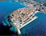
Korcula is a medieval town which, like most coastal towns, is fortified. Has been constructed on a plan shaped herringbone around the main street. Korcula is also known to house (according to legend) the house that saw Marco Polo.The ferry port is located on the E side of town. ...
Uvala Tatinja is separated from Uvala Prvi Zal to E, with a small pointe.Elle PLGA has a bottom and a dam that houses the BN. We anchor by 6 m in front of the entrance to the small port, or 4 m in the harbor. Good protection from W to E through S.


 môle S
 môle S


 Orebic is situated on the southwestern part of the Peljesac peninsula at the bottom of the hill of St. Ilija.
 Orebic est situé sur la partie sud-ouest de la péninsule de Peljesac au pied de la colline de St Ilija.