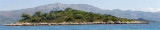
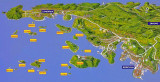
Otok Vrnik Korcula

Otok Vrnik Korcula

To precisely geolocate this site. Update if necessary.

Localisation

Characteristics

Island / Atoll
Port quai
Mooring
Sand

Description

Otok Vrnik Korcula
Otok Vrnik Korcula
2011-05-15
Update
Jojo
Otok Vrnik Korcula
Otok Vrnik Korcula
2011-05-15
Update
Jojo
Otok Vrnik Korcula
Otok Vrnik Korcula
2011-05-15
Update
Jojo
Ebook

Dubrovačko-neretvanska županija (Dubrovnik–Neretva

  • 138 sites
  • 228 photos
  • publication date: 9 Jul 2023
  • .pdf file size: 74 Mb
The small inhabited island of Korcula Vrnik is separated by a channel about 0.1 nm wide by 5 m deep.
A hamlet northwest of the island has a small jetty where you can dock by 8 m.
Good shelter except the SE.
No service.
Approaching from the NW Jezevica kanal, attention to advanced shallow (2.5 m) from Rt Soline O. Korcula, which extends over 0.1 nm to the NE.
On the other side of the channel, the W O. Planjac, a tag without fire indicates rocks awash in its S and SW.
Approaching from the NE, careful Greben Kratovicé (rock and dangerous shoal) O NE. Vrnik.
Approaching from the SE, pass between Hrid Knezic small island northeast of Uvala Tatinja) and O. Gubavac.
At E Hrid Knezic is the shoal Bili Zal, within 5 m of water.
2011/05/16
Update
Jojo
Otok Vrnik Korcula
Otok Vrnik Korcula
2011-05-16
Update
Jojo
La petite île habitée de Vrnik est séparée de Korcula par un chenal d'environ 0,1 NM de large de 5 m de profondeur.
Un hameau au NW de l'île offre un petit débarcadère où l'on peut accoster, par 8 m.

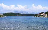
Bon abri sauf du SE.
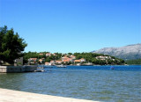
Aucun service.

En approchant par Jezevica kanal au NW, attention à l'avancée peu profonde (2,5 m)qui part de Rt Soline sur O. Korcula, et qui s'étend sur 0,1 NM vers le NE.
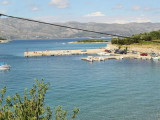
De l'autre côté du chenal, à l'W d'O. Planjac, une balise sans feu indique des rochers à fleur d'eau, dans son S et son SW.

En approchant par le NE, attention à Greben Kratovica (rocher et haut-fond dangereux) au NE d'O. Vrnik.

En approchant par le SE, passer entre Hrid Knezic petite île au NE d'Uvala Tatinja) et O. Gubavac.
A l'E de Hrid Knezic se trouve le haut-fond Bili Zal, sous 5 m d'eau.

2011/05/15
Update
Jojo
Ebook

Dalmacija (Dalmatie)

  • 542 sites
  • 910 photos
  • publication date: 9 Jul 2023
  • .pdf file size: 302 Mb
Share your comments or photos on "Otok Vrnik Korcula"

Sites around Otok Vrnik Korcula

Flying distances - Direct line

Otoci Skoji Korcula

0.7nm
38°
Skoji is a group of islands in Korcula Archipelago, located in Peljesac Channel in Croatia. There are all together 19 small islands that form this archipelago. Their names are : Badija, Kamenjak, Gojak, Planjak, Vrnik, Majsan, Majsanic, Gubavac, Knezic, Bisace, Sutvara, Stupe, Baretica, ...
15 May 11
Jojo

Otocic Badija Korcula

1.2nm
338°
Badija is one of the largest island in the Korcula archipelago.
It is situated on the east side of Korcula Old Town , about twenty minutes boat ride from Korcula's harbour. It cover the area one square km and is covered by dense maquis pine and cypress trees. Badija was ...
14 May 11
Jojo

Uvala Prvi Zal Lumbarda

0.6nm
180°
Uvala Prvi Zal, faces the island Gubavac on the NE coast of O. Korcula has a marina. Basically there is a beach.
We anchor by 3 to 5 m SE of the bay.
Attention to the rock and the shallow area extending to the middle of the bay, indicated with a green tag without fire.
Good protection.
16 May 11
Jojo

Marina Lumbarda Korcula

0.6nm
175°
The marina is located SE of uvala Prvi Zal, at the entrance of the bay.
Beware shoal located SW of the breakwater.
90 B.
Tel: +385 71 020 24 89
Fax: +385 71 020 24 79
It docks where there is room.
16 May 11
Jojo

Uvala Rascisce (Porto Bufalo) Korcula

0.6nm
222°
The bay is lined with houses located in SW O. Vrnik, O. Korcula.
Careful not to anchor near the entrance (cable).
We anchored SW of the entrance between 5 and 3 / 4 m deep.
16 May 11
Jojo

Uvala Tatinja Korcula

0.7nm
158°
Uvala Tatinja is separated from Uvala Prvi Zal to E, with a small pointe.Elle PLGA has a bottom and a dam that houses the BN.
We anchor by 6 m in front of the entrance to the small port, or 4 m in the harbor.
Good protection from W to E through S.
16 May 11
Jojo