Some of the islands are inhabited (Vrnik), and on some there are cultural remains in its ruins (Majsan).
2011/05/15
Update
Jojo
Les iles de Skoji sont des iles inhabitées de l’archipel de
Korcula;elles se situent dans le détroit de Peljesac.Il y a 19 petites
iles qui forment l’archipel de Korcula.
Elles s’appellent: Badija (dérivé du mot abbaye) où se trouve le monastère du 16° siécle - Kamenjak (ile de pierres)- Gojak, Planjak (la seule ile avec de l’eau potable)- Majsan ( jadis colonisée par les romains) - Majsanic - Gubavac - Knezic -Bisace - Sutvara - Stupe (où il y a un restaurant )- Baretica ( le nom signifie petit chapeau )- Lucnjak- Sestrice Male ( le nom signifie les petites soeurs )- Velike Sestrice (le nom signifie les grandes soeurs;il y a un phare) et Skrpinjak.
Les iles de Skoji se situent près de la cote Est de l’ile de
Korcula,pas loin de la vieille ville de Korcula et du village de
Lumbarda.
Certaines de ces iles sont peuplées ( Vrnik), d’autres ont été abandones par la civilisation (Majsan).
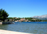
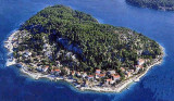
The small inhabited island of Korcula Vrnik is separated by a channel about 0.1 nm wide by 5 m deep. A hamlet northwest of the island has a small jetty where you can dock by 8 m. Good shelter except the SE. No service. Approaching from the NW Jezevica kanal, attention ...
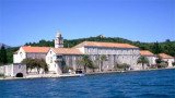
Badija is one of the largest island in the Korcula archipelago. It is situated on the east side of Korcula Old Town
, about twenty minutes boat ride from Korcula's harbour. It cover the
area one square km and is covered by dense maquis pine and cypress
trees.
Badija was ...
The mooring and dock are Badija S of the island. We can not approach the E by the passage between the islands and Badija Planjak. This shallow, rocky passage is blocked by tags. The safest approach and easiest way is via the N, the channel between Badija and Korcula. Is the ...
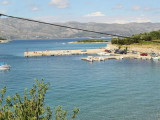
Uvala Tatinja is separated from Uvala Prvi Zal to E, with a small pointe.Elle PLGA has a bottom and a dam that houses the BN. We anchor by 6 m in front of the entrance to the small port, or 4 m in the harbor. Good protection from W to E through S.
The marina is located SE of uvala Prvi Zal, at the entrance of the bay. Beware shoal located SW of the breakwater. 90 B. Tel: +385 71 020 24 89 Fax: +385 71 020 24 79 It docks where there is room.
Uvala Prvi Zal, faces the island Gubavac on the NE coast of O. Korcula has a marina. Basically there is a beach. We anchor by 3 to 5 m SE of the bay. Attention to the rock and the shallow area extending to the middle of the bay, indicated with a green tag without fire. Good protection.


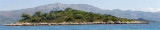
 Skoji is a group of islands in Korcula Archipelago, located in Peljesac Channel in Croatia. There are all together 19 small islands that form this archipelago. Their names are : Badija, Kamenjak, Gojak, Planjak, Vrnik, Majsan, Majsanic, Gubavac, Knezic, Bisace, Sutvara, Stupe, Baretica, Lucnjak, Sestrice (Vela and Mala Sestrica), Gubavac and Skrpinjak.
 Les iles de Skoji sont des iles inhabitées de l’archipel de
Korcula;elles se situent dans le détroit de Peljesac.Il y a 19 petites
iles qui forment l’archipel de Korcula.
Les iles de Skoji sont des iles inhabitées de l’archipel de
Korcula;elles se situent dans le détroit de Peljesac.Il y a 19 petites
iles qui forment l’archipel de Korcula.