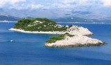
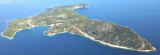
Otok Sipan
9.4nm
295°
Ruda is a small island that is 0.5 M SE of the NE extremity of the island and Misnjaka, 13 m high, lies close off the NW extremity.
...
16 Apr 11
Jojo
| Latitude | Longitude | |
| DMS | --- | --- |
| DM | --- | --- |
| DD | --- | --- |


 cybercafé


 Gruz is the commercial port of Dubrovnik and has heavy traffic of freighters, ferries and cruise ships. This is the port of entry and a portion of the dock, beyond the location of Ferries, is reserved for the craft. This is the "Marina", pay, noisy and skirted by the very busy road, which is certain disadvantages.
 Gruz est le port de commerce de Dubrovnik et a un trafic important de cargos, Ferries et paquebots. C'est le port d'entrée et une partie du quai, au delà de l'emplacement des Ferries, est réservée à la plaisance. C'est la "marina", payante, bruyante et longée par la route très passante, ce qui constitue des inconvénients certains.
L'entrée du port de Gruz est au S de Rt Kantafig, virer vers le port et se diriger au SE vers le quai qui porte le feu. Une bouée cylindrique rouge sans feu, située à environ 0,3 M au SE de Rt Kantafig et à 100 m à l'W du quai, indique un rocher sous 4,5 m d'eau. Une bouée jaune sans feu, à 0,2 M au S de cette bouée rouge indique une épave.
Bon abri mais ressac dû au passage des bateaux.
Ebook | Dubrovačko-neretvanska županija (Dubrovnik–Neretva
|