Suitable only as a temporary refuge from the bora. When other winds start
blowing, especially westerlies or south westerlies, yachts should leave without
delay. It provides no adequate shelter from the sirocco either, since this wind
is apt to change its direction to the SW in these parts.
Yachts can anchor in the inner part of the cove (depths 5-10 m).
2011/05/24
Update
Jojo
Bisevska Luka est une anse de la côte Ouest de Bisevo. Convient uniquement comme un refuge temporaire de la bora. Quand d'autres vents commencent à souffler, en particulier d'ouest ou de SW, les yachts doivent partir sans délai. Il n'y a aucune protection contre le sirocco, car ce vent est de nature à changer sa direction vers le SW dans ces régions. Les yachts peuvent jeter l'ancre dans la partie intérieure de l'anse (par 5 à 10 m).
Otok Svetac (Andrija), 305m high, lies 13 miles ESE of Otocic Jabuka and is generally steep-to. The coast of the island is rocky and reddish in color on the NW side. Its SW end is fronted by a few rocks. Hrid Kamik, a dark and jagged above-water rock, lies 0.7 mile W of the SW extremity ...
Bisevo is located SW of Vis, 4 NM Komiza. This small inhabited island has an area of 5.8 sq. km. The highest point is Strazenica (239 m). The islanders live from fishing and agriculture. On its shores steep, there are many caves, the most famous is the Blue Cave (18 m long, 6 m ...
Bisevski Kanal, 2.2 miles wide, leads between Otok Bisevo and Otok Vis. This channel, in good weather, can be used to advantage to shorten the route out of the Adriatic. However, in winter with strong winds and currents it is best avoided.
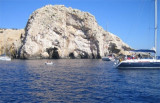
Balun is a cove in the E coast of the island of
Bisevo, just S after Hr Tocac .The famous Blue Cave (Modra spilja) is situated in this cove. At noon, when the
sea is calm, sunrays penetrating into the cave through an underwater opening are
reflected from the white bottom, ...
Plakeni islands, or Cursed Islands, are located at the W and S of Hvar town.
The islands are rocky, covered with bushes and trees. They are usually deserted, except in summer. They offer many choices of moorings sheltered and there is a marina Palmizana.The islands'name ...


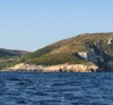
 Bisevska Luka is a cove in the W coast of Bisevo.
 Bisevska Luka est une anse de la côte Ouest de Bisevo.